伊朗南部高扎格羅斯?jié)岱e放射蟲巖亞帶的放射蟲地層學(xué)
伊朗南部高扎格羅斯?jié)岱e放射蟲巖亞帶的放射蟲地層學(xué)
Zagros orogen extends from the Turkish-Iranian border to NW, to the Makran area in SE. According to Geological Survey of Iran 100,000 series “Sureyan”,“Saadatshahr”, “Abadeh-E-Tashk” and “Arsenjan”, the Zagros orogen comprises the following sub-parallel tectonostratigraphic domains, from SW to NE: the Zagros foreland basin, the Simply Foloded Belt, the more mountainous part of the Zagros proper (including the High Zagros and the Crush Zone) and domains that can be thought of belonging to the Zagros orogen in a broader sense: the SSZ (Sanadaj-Sirijan Zone),the UDMA (Urumiyeh-Dokhtar Magmatic Arc) and the western parts of Central Iran.

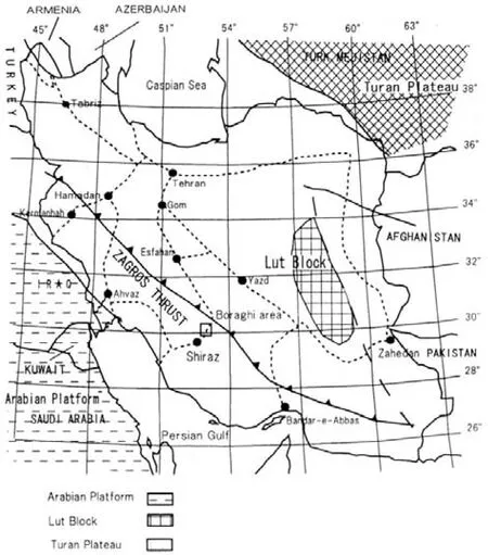
Fig. 1 Location map of the studied area (square)
The authors have studied the geology of the Tang-e-bolagi and Arsenjan areas which are located in the High Zagros since 2005 (Fig.1). These works are a joint work with archaeologists for clarifying the good raw material for making stone tools. As a result, we could get to the conclusion that some radiolarite rather than chert and siliceous nodule could be best stone tools (Tsuneki and Zeidi eds., 2008). In addition, the areal distribution of radiolarite is characteristically limited and this might be caused by structural and stratigraphical constrains. In this paper, the occurrence of radiolarite in the High Zagros is mentioned and its tectonic significance is discussed.
The stratigraphy of the Dalnesin valley in the Arsenjan area (Fig.1) was established in this study.Three lithological units could be recognized; fossiliferous limestone, bedded limestone and radiolarite units. The fossiliferous limestone unit is characterized by the occurrence of stromatoporoids and corals.This occurrence is very similar to that of the Torinosu limestone which is one of the representative Upper Jurassic facies in Japan (Prof. Yamagiwa, in personal.comm.). The limestone is thickly bedded and dark gray in color. This unit occurs at the inner part of the Dalnesin valley.
The bedded limestone unit occurs extensively on the northern side of the Dalnesin valley. This unit is making a spectacle there, that is, a cliff more than 500 m high. On the foot of this cliff, there are isolated smaller hills where argillaceous bedded limestone is distributed. The observed stratigraphy at the hill in ascending order is as follows;
Yellow muddy limestone facies (30 m thick)
Pebble-sized limestone conglomerate facies (20 m thick)
Muddy limestone facies (60 m thick)

Fig. 2 Geologic map of the Dalnesin valley1-6-bedded limestone unit(1-thickly bedded limestone facies; 2-cobble-sized limestone conglomerate facies; 3-muddy limestone facies;4-pebble-sized limestone conglomerate facies; 5-yellow muddy limestone facies; 6- bedded limestone); 7-9-radiolarite units(7-alternation of limestone and radiolarite subunit; 8-alternation of brown shale and radiolarite subunit; 9-gray limestone); 10-fossiliferous limestone unit
Cobble-sized limestone conglomerate facies (30 m thick)
Thickly bedded limestone facies (30 m thick)
These beds dip southerly and look like the concordant contact with bedded limestone of a main part of the cliff.
The radiolarite unit is distributed in the Dalnesin valley and on the southern side. The radiolarite unit can be divided into the lower alternation of brown shale and radiolarite and the upper alternation of limestone and radiolarite subunits. The radiolarite unit presents folded structure on the outcrop scale and flat-lying structure on the large scale. Following species were identified from the radiolarite river pebble collected from the entrance part of the Dalnesin valley.These radiolarian specimens are poorly preserved.
Praecaneta mineticaDUMITRICA
Dictyomitra formosaSQUINQBOL
Stichomitracf.tosaensisNAKASEKO &NISHIMURA
Archeodictyomitrasp.
Stichomitrasp.
Spumellaria gen. et sp. indet.
Nassellaria gen.et sp. indet.
The occurrence ofP. mineticawas reported from the Early Cretaceous of the Mailolica Formation distributed in the Southern Alps and Umbria-Marche Apennines by Jud (1994) and Dumitrica et al. (1997).This species has a range from Berriasian to Barremian and is commonly found in the Hauterivian and Barremian.D. formosais diagnostic spicies of the early Late Cretaceous ( Cenomanian to Turonian ) and occurs from all over the world (e.g., O’Dogherty, 1994).The range ofStichomitra tosaensiswas the late Early to early Late Cretaceous of the Albian to Cenomanian.Radiolarian fauna is monotonous and poorly preserved,however, occurrence of these radiolarians indicates that the radiolarite was deposited in the Early to early Late Cretaceous. The radiolarite unit seems to overlie the bedded limestone unit in the outer part of the Dalnesin valley.
The presence of the Arsenjan fault has not been confirmed along the Dalnesin valley. According to the geologic map 100,000 series of “Arsenjan” published by Geological Survey of Iran, the limestone beds on the northern side of the valley were overturned because of the reverse sense of the Arsenjan fault, and now overlie the radiolarite unit on the southern side. However, both units appear to be concordant. If this assumption is correct, the radiolarite unit seems to correspond to the axial trace of an E-W trending syncline.
Therefore the present study reveals that the stratigraphy of the High Zagros in the Arsenjan area is the Upper Jurassic ? fossiliferous limestone unit, bedded limestone unit and the Lower to “Middle” Cretaceous radiolarite unit in ascending order.
DUMITRICA P, IMMENHAUSER A, JUD R. 1997. Mesozoic radiolarian biostratigraphy from Masirah ophiolaite, Sultanate of Oman. Bulletin of the national Museum of Natural Science,9: 1-106.
JUD R. 1994. Biochronology and Systematics of Early Cretaceous radiolarian of the Western Tethys. Memoires de Geologie,19:147.
O’DOGHERTY L. 1994. Biochronology and Paleontology of Mid-Cretaceous Radiolarians from Northern Apennines ((Italy)and Betic Cordillera (Spain). Memoires de Geologie, 21:413.
TSUNEKI A, ZEIDI M EDS. 2008. TANG-E BOLAGHI, The Iran-Japan Archaeological Project for the sivand Dam Salvage Area. Department of Archaeology, History & Anthropology,Graduate School of Humanities and Social Sciences, University of Tsukuba (Al-Shark; University of Tsukuba, Studies for West Asian Archaeology, No.3): 261.
Stratigraphy of Radiolarite in the Turbiditic Radiolaritic Subzone of the High Zagros, Southern Iran
Ken-ichiro HISADA, Yoshihito KAMATA
Graduate School of Life and Environmental Sciences, University of Tsukuba, Ibraki305-8572,Japan
Zagros; southern Iran; radiolarite; Cretaceous; Jurassic
10.3975/cagsb.2012.s1.10
book=20,ebook=125

