
Evaluation on Terrain-Climate Superiority Degree at County Level in Yunnan Province
2021-10-21 09:13:36RenyiYANGZishengYANG
Asian Agricultural Research 2021年8期
Renyi YANG, Zisheng YANG
Institute of Land Resources and Sustainable Development, Yunnan University of Finance and Economics, Kunming 650221, China
Abstract Terrain slope and climate zone (heat zone) are important factors affecting land use zoning and agricultural production layout in mountainous areas. Using "weight grade method", a quantitative index of comprehensively evaluating terrain slope and climatic (thermal) conditions in mountainous areas was proposed: terrain-climate superiority degree (TCSD), and TCSD, terrain superiority degree (TSD), and climate superiority degree (CSD) in 129 counties (cities and districts) of Yunnan Province were measured and analyzed. The results showed that TCSD in 50.39% of counties of Yunnan Province was relatively better (levels I and II), and TCSD in 38.76% of counties was moderate (level III), while TCSD in 10.85% of counties was relatively poorer (levels IV and V).
Key words Terrain slope, Climate zone, Terrain-climate superiority degree, County level, Evaluation
1 Introduction
Yunnan is a typical mountainous province in the southwest frontier of China. Mountainous area in Yunnan Province accounts for 93.60% of total land area, and flatland area with gentle terrain only accounts for 6.40%. Because that the landform of Yunnan is dominated by mountainous areas, and it generally presents the characteristics of "high mountains, steep slopes and deep valleys", it makes the climate correspondingly show the remarkable characteristics of "three-dimensional climate". From south to north and from low altitude to high altitude, Yunnan Province spans seven climatic zones, including north tropical zone, south subtropical zone, middle subtropical zone, north subtropical zone, warm temperate zone, temperate zone and cold temperate zone. In land use zoning and agricultural production layout, terrain slope and climate zone (heat zone) are extremely important factors. Terrain slope is directly related to the degree of water and soil loss, irrigation and drainage facilities, tractor farming conditions, terrace construction and many other aspects, thus affecting the rational allocation of agricultural, forestry and animal husbandry land. Generally speaking, limit slope of land use is 35°, while the reclaimed slope of farmland shall be limited to 25°, and it is also upper limit slope of reclamation prohibition stipulated by theLaw
of
the
People
’s
Republic
of
China
on
Water
and
Soil
Conservation
. Altitude (heat zone) directly affects land use mode, crop layout and farming system, and is an important factor determining land suitability and regional layout of agricultural industry. In addition, topographic and climatic conditions are often extremely important and non-negligible factors restricting the development of a region. Many studies have shown that the terrain and climate conditions of a region will have a direct or indirect impact on its economic development, poverty, income conditions of residents, urban-rural income gap and so on. Some scholars even use spatial econometric models to explore the impact mechanism of terrain and climate conditions on urban-rural income gap. However, when evaluating terrain slope and climate zone (heat zone), single-factor analysis and evaluation are often carried out separately, and there are few practices and examples of organic combination of these two factors for comprehensive evaluation. It is not favorable for comprehensive evaluation of terrain and climate in the analysis and research of land use, agricultural production layout and economic development in mountainous areas. In this paper, Yunnan Province was taken as research object, and a quantitative method of organically combining terrain slope with climate zone (heat zone) for comprehensive evaluation was explored. The research could lay better basic basis for analysis and study on land use zoning, agricultural production layout and economic development in mountainous areas.2 Study methods and data source
2.1 Study methods
To comprehensively evaluate the superiority degree of terrain slope and climate zone (heat zone), a comprehensive quantitative evaluation index is introduced, namely "terrain-climate superiority degree" (TCSD
).TCSD
is measured by weight grade method. Weight grade method uses a comprehensive index to reflect overall relative level of multiple indicators, and can conduct intuitive and quantitative comparison and evaluation. Specific method ofTCSD
could be expressed as:TCSD
=w
·TSD
+w
·CSD
(1)
whereTCSD
is comprehensive terrain-climate superiority degree;TSD
is terrain superiority degree;CSD
is climate superiority degree;w
andw
are weight coefficients ofTSD
andCSD
.2.1.1
Measurement method ofTSD
. In Yunnan, terrain slope is generally divided into five grades: ① ≤8°, ② 8-15°, ③ 15-25°, ④ 25-35°, ⑤ >35°. When Yunnan Office of Agricultural Zoning Commission measured land area with different slope grades in each county of the province in 1987, area of land at the five slope grades and other areas such as "water surface" were measured. Using "weight grade method",TSD
in each county could be measured:TSD
=w
1·ARS
+w
1·OAR
(2)
whereTSD
is terrain superiority degree;ARS
is area ratio of different slopes;w
1is weight coefficient of area ratio of different slopes;OAR
is other area ratio such as "water surface";w
1is weight coefficient of other area ratios.2.1.2
Measurement method ofCSD
. According to altitude and heat conditions, there are seven climatic zones in Yunnan, namely north tropical zone, south subtropical zone, middle subtropical zone, north subtropical zone, warm temperate zone, temperate zone and cold temperate zone. Among them, north tropical zone and south subtropical zone belong to "low thermosphere"; middle subtropical zone, north subtropical zone, and warm temperate zone could be merged into "mesothermal layer"; temperate zone and cold temperate zone belong to "alpine layer". When Yunnan Office of Agricultural Zoning Commission measured land area of different slope grades in each county of whole province in 1987, land area and other areas such as "water surface" of the seven climate zones were measured. Using "weight grade method",CSD
in each county could be measured:CSD
=w
2·ARC
+w
2·OAR
(3)
whereCSD
is climate superiority degree;ARC
is area ratio of different climatic zones;w
1is weight coefficient of area ratio at different altitudes;OAR
is other area ratio such as "water surface";w
2is weight coefficient of other area ratio.2.1.3
Determination method of each weight coefficient. There are many methods to determine the weight, such as entropy weight method and AHP method, which have their own advantages and disadvantages. Some studies use these methods comprehensively to give better play to the advantages of various methods. In order to facilitate the research, the Delphi method is used in this paper. Experts are organized to assign or score the weight of each factor. After feedback of probability estimation results, experts score the weight of each factor in the second and third rounds, making the decentralized assignment converges gradually, and finally obtaining collective judgment result value with high accuracy. According to Delphi method, 15 experts with relevant professional background (land use planning, agricultural geography, ecology, and economics) were organized to assign the weights of the above factors. After corresponding treatment, weight value of index at each layer was obtained (Table 1).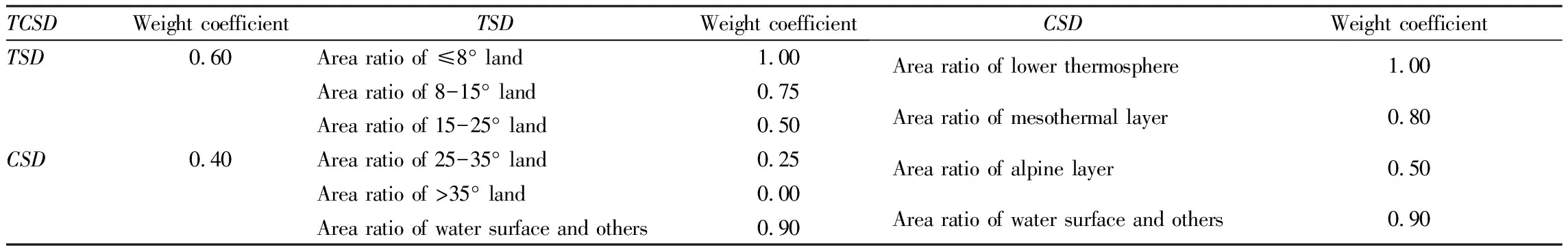
Table 1 Evaluation factors of TCSD in mountainous areas and their weight values
2.2 Data source
Basic data of measuringTCSD
(land area of different climatic zones and slopes at each county-level administrative unit) were from theLand
Area
of
Different
Climatic
Zones
and
Slopes
in
Yunnan
Province
published by Yunnan Office of Agricultural Zoning Commission in 1987. In a few counties whose administrative divisions have changed since 1987, it was corrected according to the second national land survey and digital elevation model map of Yunnan Province.3 Measurement results and analyses
3.1 Measurement results
According to above methods,TCSD
,TSD
andCSD
in 129 counties of Yunnan Province were predicted (Table 2).3.2 Analysis and evaluation on
3.2.1
Analysis onTSD
. Measurement results showed that there were great differences inTSD
at county level of Yunnan Province.TSD
in Chenggong District, Luliang County, Zhanyi District, Shilin County, Guandu District, Panlong District, Qilin District, Wuhua District and Malong County of central and eastern Yunnan reached more than 80, which was larger, showing that the terrain condition was relatively better. In Yunlong County, Jinping County, Yuanjiang County, Daguan County, Yuanyang County, Lanping County, Hekou County, Qiaojia County, Dongchuan District, Pingbian County, Xichou County, Weixi County, Malipo County, Luchun County, Lushui City, Fugong County, Deqin County, and Gongshan County of northwest, northeast and southeast mountainous areas of Yunnan,TSD
was all lower than 35, which was smaller. It indicated that the terrain condition was relatively poorer.According toTSD
in each county (city and district), via repeated analysis,TSD
in 129 counties (cities and districts) of Yunnan Province could be divided into five grades (Table 3). Grading results showed that there were nine counties thatTSD
was more than or equal to 80 (level I), which accounted for 6.98% of total county number in whole province. There were 10 counties thatTSD
was between 65 and 80 (level II), which accounted for 7.75% of total county number in whole province. There were 36 counties thatTSD
was between 50 and 65 (level III), which accounted for 27.91% of total county number in whole province. There were 56 counties thatTSD
was between 35 and 50 (level IV), which accounted for 43.41% of total county number in whole province. There were 18 counties thatTSD
was below 35 (level V), which accounted for 13.95% of total county number in whole province. It was clear thatTSD
in 57.36% of counties in Yunnan Province was relatively poorer (levels IV and V), andTSD
in 27.91% of counties was moderate (level III), whileTSD
at levels I and II only accounted for 14.73%.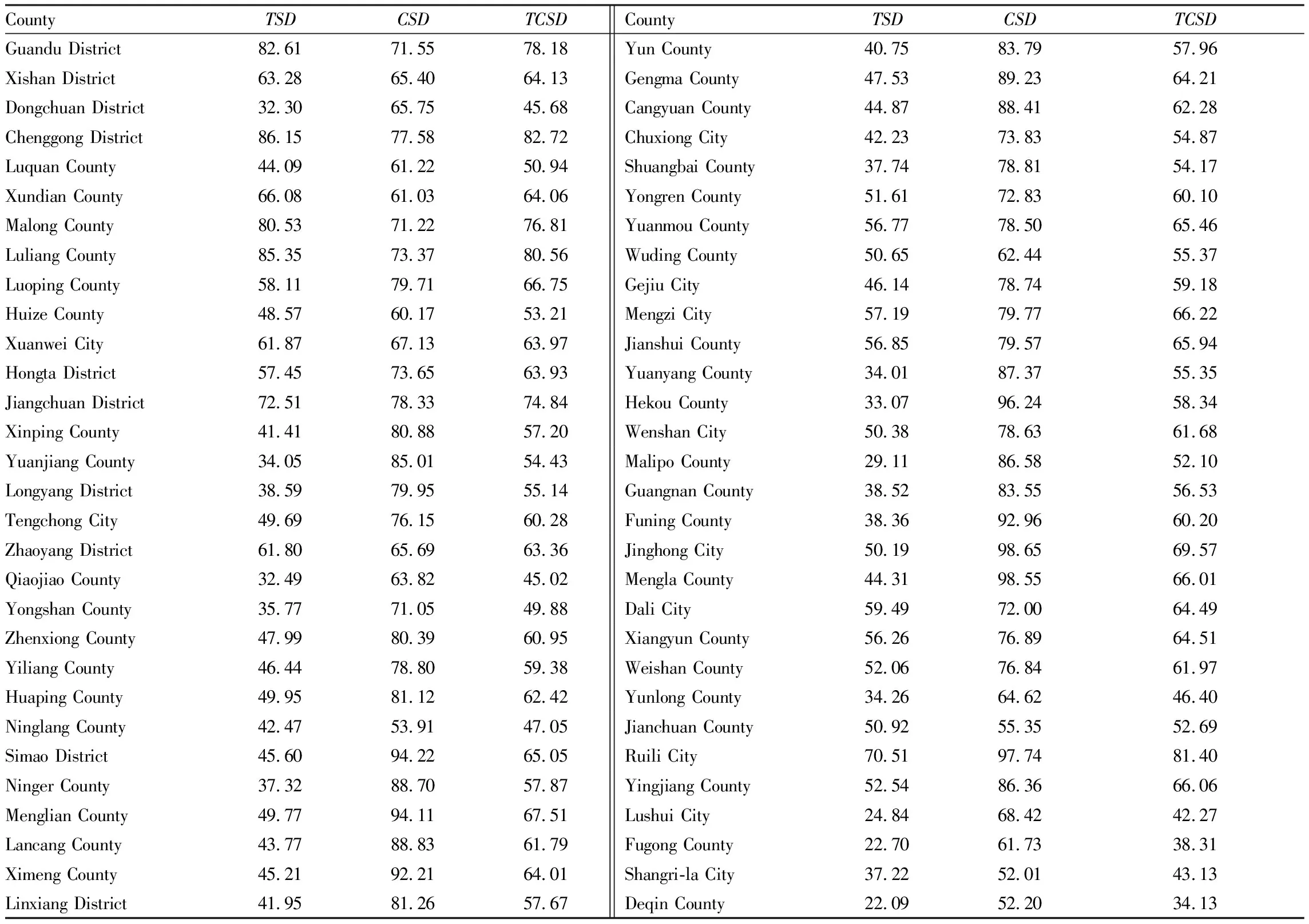
Table 2 TCSD, TSD and CSD in each county of Yunnan Province
3.2.2
Analysis onCSD
. According to measurement results, the difference ofCSD
at county level of Yunnan Province was also significant.CSD
in Jinghong City, Mengla County, Ruili City, Hekou County, Jiangcheng County, Simao District, Menglian County, Funing County, Menghai County, Ximeng County, Mang City, Jinggu County, Longchuan County, Luchun County, Mojiang County in low latitude of south Yunnan, and Yanjin County, Suijiang County, and Shuifu County of low heat valley area of the Jinsha River was all more than 90, which was larger. It showed that the climate (heat) conditions were relatively better. In Gucheng District, Lanping County, Yulong County, Gongshan County, Weixi County, Jianchuan County, Ninglang County, Deqin County, and Shangri-la City of alpine plateau region of northwest Yunnan,CSD
was all less than 60, which was smaller. It indicated that the climate (heat) conditions were relatively poorer.According toCSD
at each county (city and district), via repeated analysis,CSD
at 129 counties of Yunnan Province was divided into five levels (Table 4). Grading results showed that there were 18 counties thatCSD
was more than or equal to 90 (level I), which accounted for 13.95% of total county number in whole province. There were 32 counties thatCSD
was between 80 and 90 (level II), which accounted for 24.81%. There were 48 counties thatCSD
was between 70 and 80 (level III), which accounted for 37.21%. There were 22 counties thatCSD
was between 60 and 70 (level IV), which accounted for 17.05%. There were nine counties thatCSD
was less than 60 (level V), which accounted for 6.98%. It was clear thatCSD
in 38.76% of counties in Yunnan Province was relatively better (levels I and II);CSD
in 37.21% of counties was moderate (level III);CSD
in 24.03% of counties was relatively poorer (levels IV and V).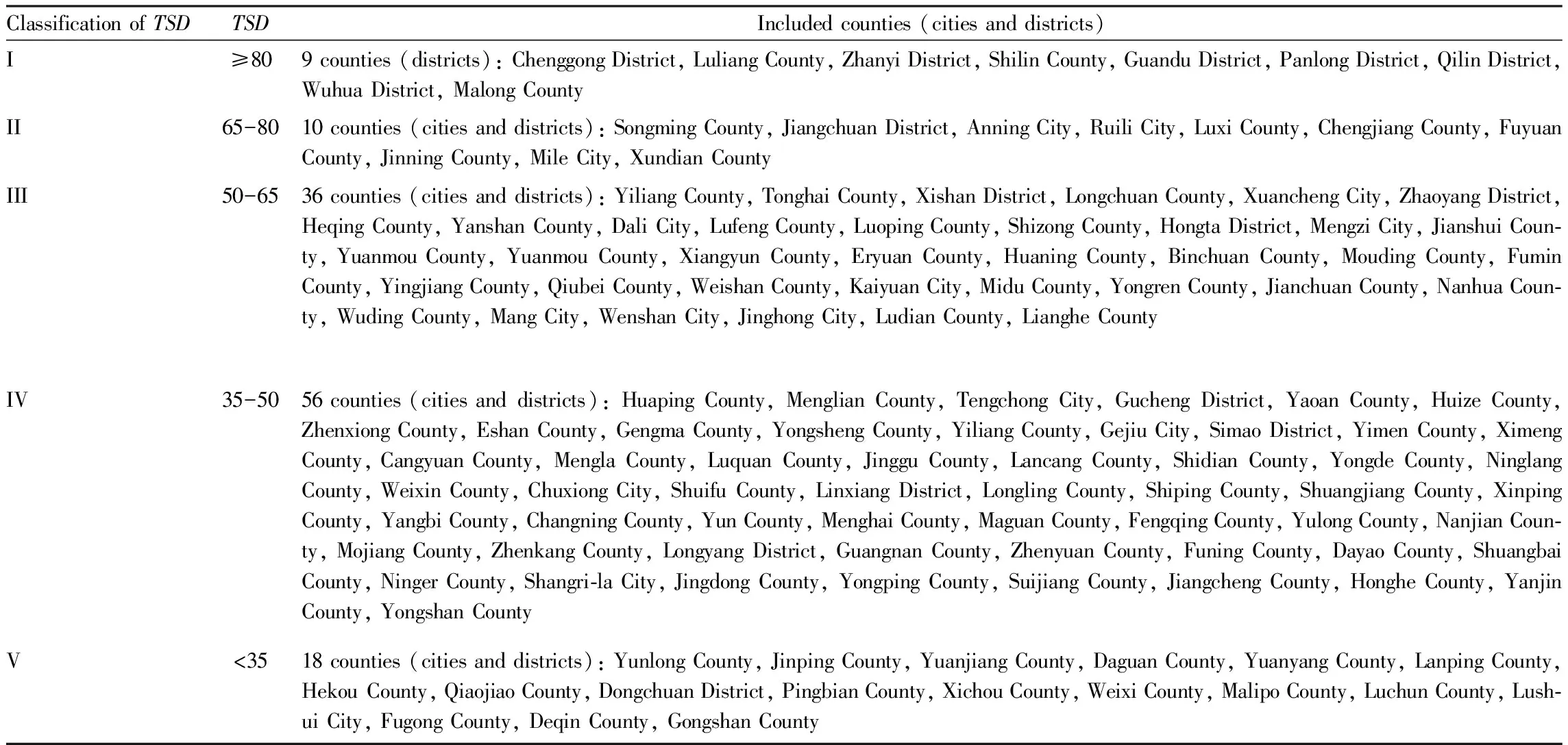
Table 3 Classification of TSD at county level of Yunnan Province
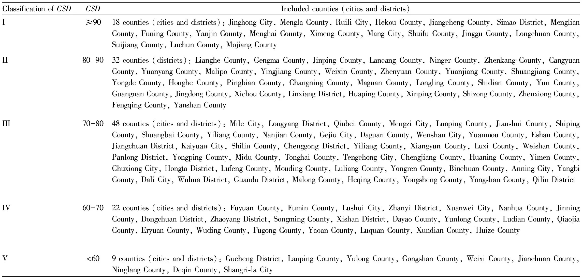
Table 4 Classification of CSD at county level of Yunnan Province
3.2.3
Analysis onTCSD
.TCSD
is comprehensive result of organically combiningTSD
withCSD
. Measurement results showed that the difference inTCSD
at county level of Yunnan Province was significant.TCSD
in Chenggong District, Shilin County, Panlong District, Guandu District, Wuhua District, Jiangchuan District, Songming County, Chengjiang County, and Anning City of central Yunnan, Luliang County, Zhanyi District, Qilin District, and Malong County of east Yunnan, Ruili City, Longchuan County of southwest Yunnan, and Luxi County and Mile City of southeast Yunnan was all more than 70, which was larger. It showed that the terrain and climate (heat) conditions were relatively better. In Yongshan County, Dayao County, Ninglang County, Yulong County, Yunlong County, Dongchuan District, Qiaojia County, Shangri-la City, Lanping County, Lushui City, Weixi County, Fugong County, Deqin County, and Gongshan County of northwest and northeast Yunnan was all less than 50, which was smaller. It indicated that the terrain and climate (heat) conditions were relatively poorer.According toTCSD
in each county (city and district), via repeated analysis,TCSD
in 129 counties (cities and districts) of Yunnan Province was divided into five grades (Table 5). Grading results showed that there were 17 counties thatTCSD
was more than or equal to 70 (level I), which accounted for 13.18% of total county number of whole province. There were 48 counties thatTCSD
was between 60 and 70 (level II), which accounted for 37.21%. There were 50 counties thatTCSD
was between 50 and 60 (level III), which accounted for 38.76%. There were 11 counties thatTCSD
was between 40 and 50 (level IV), which accounted for 8.53%. There were three counties thatTCSD
was less than 40 (level V), which accounted for 2.33%. It was clear thatTCSD
at 50.39% of counties in Yunnan Province was relatively better (levels I and II);TCSD
at 38.76% of counties was moderate (level III);TCSD
at 10.85% of counties was relatively poorer (levels IV and V).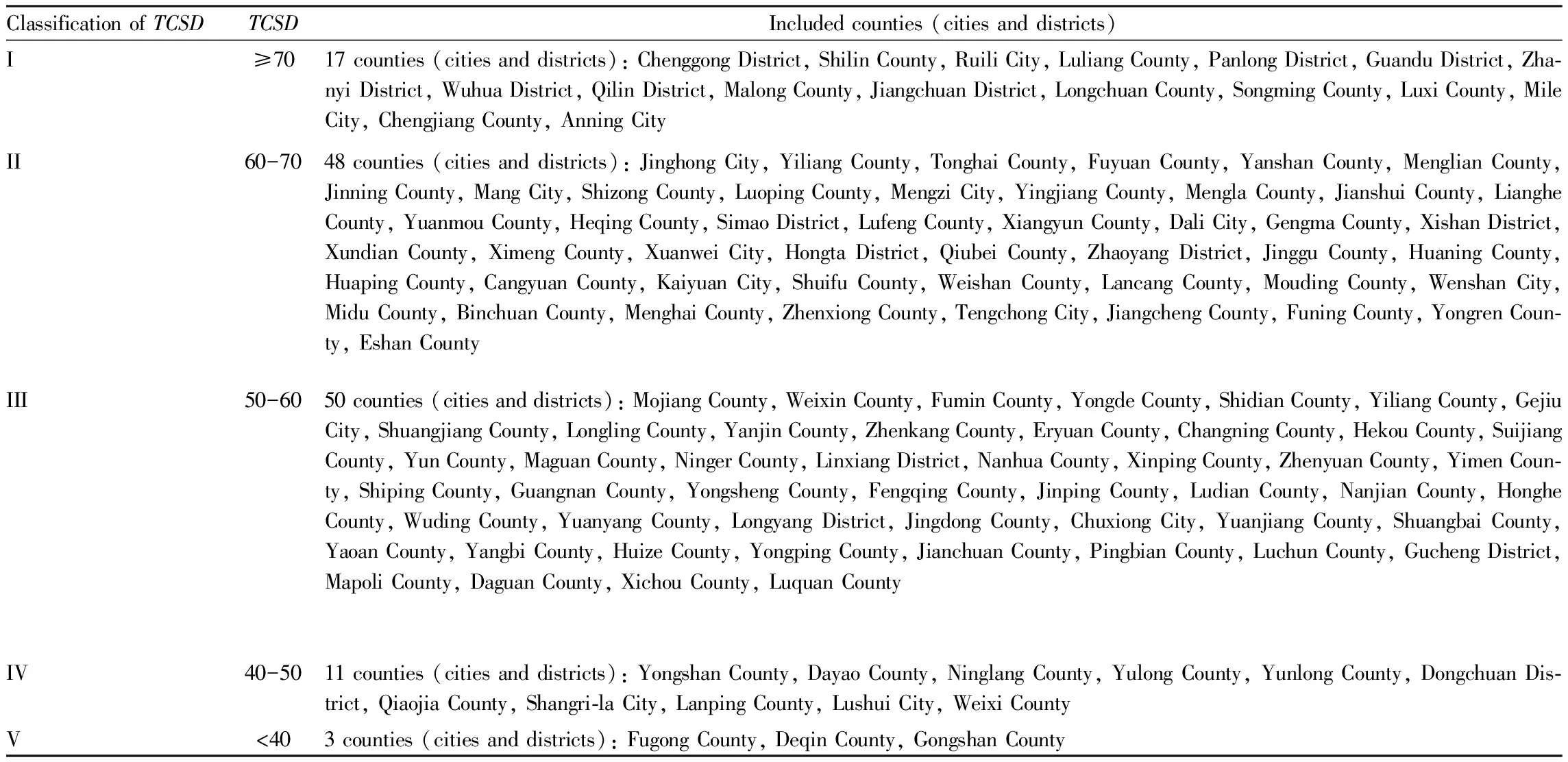
Table 5 Classification of TCSD at county level of Yunnan Province
4 Conclusions
The terrain and climate conditions of mountainous provinces are complex. When analyzing influence factors of land use and agricultural production layout, it needs comprehensively measuring and considering terrain slope and climate (heat) conditions, to better understand the comprehensive situation of natural conditions in mountainous areas (natural endowment, advantages and disadvantages). Based on land area of different climatic zones and slopes in Yunnan Province measured by Yunnan Office of Agricultural Zoning Commission, "weight grade method" was used, and a quantitative index of comprehensively evaluating terrain slope and climate (heat) conditions in mountainous areas—TCSD
was introduced. In this paper,TCSD
,TSD
, andCSD
in 129 counties (cities and districts) of Yunnan Province were measured and analyzed.(i) As typical province of frontier mountainous areas in Southwest China, the difference inTSD
was larger at county level of Yunnan Province.TSD
in 57.36% of counties was relatively poorer (levels IV and V), andTSD
in 27.91% of counties was moderate (level III), whileTSD
at levels I and II only accounted for 14.73%.(ii) The mountainous terrain characteristics of high moun-tains and deep valleys make the three-dimensional climate of Yunnan more significant, and the differences ofCSD
are also more significant.CSD
in 38.76% of counties was relatively better (levels I and II);CSD
in 37.21% of counties was moderate (level III), andCSD
in 24.03% of counties was relatively poorer (levels IV and V).(iii) As comprehensive quantitative evaluation index of organically combiningTSD
withCSD
, the difference inTCSD
was also larger at county level.TCSD
at 50.39% of counties was relatively better (levels I and II);TCSD
at 38.76% of counties was moderate (level III);TCSD
at 10.85% of counties was relatively poorer (levels IV and V). Asian Agricultural Research2021年8期
- Asian Agricultural Research的其它文章
- Attaching Importance to the Training of Young Researchers and Promoting the Echelon Construction of the Research Institute
- Research on Stimulating the County-wide Economic Vitality of Jingzhou City
- Farmers’ Ideological and Political Education under the Background of Rural Revitalization Strategy
- Study on Characteristics of Soil Seed Bank of Natural Grassland in Nierong County
- Determination of Inorganic Anions and Melamine in Fertilizers by Ion Chromatography
- Changes of China’s Position in the World Food Trade Network