A Study on the Representative Submissions of Extended Continental Shelf Involving Ridges
2018-01-22 07:51:14LIJinrong
中華海洋法學(xué)評(píng)論 2017年2期
LI Jinrong
I. Introduction
The United Nations Convention on the Law of the Sea (UNCLOS) provides that a coastal State has jurisdiction and sovereign rights over the continental shelf,which is the natural prolongation of its land territory. According to the regime of continental shelf under UNCLOS Article 76, the continental shelf of a coastal Statemay, based on the geomorphological and geological conditions of its continental margin, extend to a distance of 350 nm, or even farther, from the baselines from which the breadth of its territorial sea is measured. The outer limits of the continental shelf serve as the outermost boundary within which a coastal State may enjoy and exercise sovereign rights over the natural resources. In other words, such outer limits concern the sovereign rights of the coastal State.
In the recent two decades, the gradual discovery of hydrothermal sulfide deposits and biological genetic resources, which are of great economic value, in the mid-ocean ridge regions, brought such regions to the forefront of the scramble for continental shelves between coastal States. A coastal State may, by invoking the ridge provisions, extend the outer limits of its continental shelf beyond 200 nautical miles. In this context, the issue of ridges has become a hot topic in the delimitation of extended continental shelf.
Faced with the imprecise terminology of Article 76 (submarine elevations and ridges, and ridges of deep ocean floor present an array of definitional uncertainties),with the nonspecific wording of the Scientific and Technical Guidelines of the Commission on the Limits of the Continental Shelf (hereinafter referred to as the“Guidelines”), a coastal State needs to develop its own evaluations of whether the provisions related to ridges as invoked in its continental shelf submission are reasonable or not.1Ron Macnab, Submarine Elevations and Ridges: Wild Cards in the Poker Game of UNCLOS Article 76, Ocean Development & International Law, Vol. 39, Issue 2, 2008,pp. 223~234.Given the enormous economic interests involved, some coastal States tend to broadly interpret the ridge provisions, pursuing to extend its continental shelf to the maximum extent and further to maximize its maritime rights and interests. The outer limits of the continental shelf of a coastal State represent the outermost boundary within which that State enjoy sovereign jurisdiction, and also the line separating national continental shelf from international seabed. The scope of the international seabed area (hereinafter referred to as the “Area”) is determined, ultimately, by the delineation of the outer limits of continental shelf of each coastal State. That is to say, the outer limits of continental shelf of each coastal State is crucial in the determination of the scope of the Area. UNCLOS Article 136 articulates that the Area and its resources are the common heritage of mankind. Therefore, the extension of continental shelf would, necessarily, affect the common heritage of mankind, and also China’s rights over the resources in the deep ocean. Against this background, it is necessary to pay great attentions to the issue of ridges in continental shelf delimitation. The paper, by examining some typical submissions of extended continental shelf involving ridge provisions, explores the concrete principles on the application of such provisions, aiming to protect the maritime rights and interests of China.
II. An Overview of the UNCLOS Provisions Concerning Ridges
A. The Concept of Ridge under the UNCLOS
The term “ridge” is originally a concept of natural science, specifically, a term used in geomorphology describing the topographic characteristics of the seafloor. However, the UNCLOS, for the purpose of limiting a State’s extension of its continental shelf, lays down some provisions concerning the ridges, which are contained in paragraphs 3 and 6 of Article 76. Pursuant to the UNCLOS, the extent of continental shelf that different types of ridges may generate varies from each other. That is to say, the issue of ridge relates to the maritime and political boundary where a State enjoys sovereign rights. In this connection, the term “ridge”under the UNCLOS has acquired a legal sense. The three types of ridges under Article 76, namely oceanic ridges of the deep ocean floor, submarine ridges and submarine elevations, although originally a concept in science, have become a part of the UNCLOS. Therefore, their application and interpretation should follow the rules of international law. And the three types of ridges, as legal terms, have their own legal status and entitlements.
Article 76(3) prescribes that the continental margin does not include the deep ocean floor with its oceanic ridges or the subsoil thereof. This provision implies that an oceanic ridge of the deep ocean floor cannot generate a continental shelf beyond 200 nautical miles. Article 76, paragraph 6 imposes some restrictions on the application of the provisions under paragraph 5 with respect to submarine ridges. Paragraph 6 provides that notwithstanding the provisions of paragraph 5,“on submarine ridges, the outer limit of the continental shelf shall not exceed 350 nautical miles from the baselines from which the breadth of the territorial sea is measured.” Consequently, on submarine ridges, a coastal State may not extend its continental shelf by applying the depth constraint constructed at 100 nautical miles from the 2500 meter isobath. This restriction does not apply to “submarine elevations that are natural components of the continental margin, such as its plateaux, rises, caps, banks and spurs.” Paragraph 6 fails to directly define the term“submarine ridge”, however, it differentiates “submarine ridges” from “submarine elevations that are natural components of the continental margin”. Referring to this differentiation and the provision of paragraph 3 on ridges of deep ocean floor,we can describe submarine ridges as a part of the natural prolongation of the land territory of the coastal State, but not natural components of the continental margin. These ridges may be divided into two categories: one is the ridge which is originated from the continental margin and extends to the deep ocean seabed area;and the other is the submarine ridge which is not connected with the land mass but supports the island chain.2Satya N. Nandan and Shabtai Rosenne eds., United Nations Convention on the Law of the Sea, 1982: A Commentary, Vol. II, translated by LV Wenzheng and MAO Bin,Beijing: Ocean Press, 2014, pp. 790~792. (in Chinese)
It should be mentioned that the examples of submarine elevations listed in paragraph 6, namely, “plateaux, rises, caps, banks and spurs”, are not exhausted and complete. Such names reflect more about their geomorphological characteristics,rather than their origins or geological compositions, because one principle governing the naming of a submarine feature is that the name of the feature merely describes its geomorphological characteristics, rather than its origin or geological composition, and many geomorphological features have acquired their names long before their geological characteristics are known to the world. For example, names such as ridge, rise and seamount can be used to call some submarine features that are components of the deep ocean floor, and also be used to call features which are components of the continental margin. Notably, continental margin and deep ocean seafloor are greatly different in origin and geological composition, which complicates the extension of continental shelf based on the geomorphological characteristics of submarine features. However, if a feature can be proved to be a natural component of the continental margin, whatever its name is, be it ridge,plateau, rise or any other names, then the second sentence of paragraph 6 explicitly prescribes that the provision laid out in the first sentence should not apply to the feature.3Satya N. Nandan and Shabtai Rosenne eds., United Nations Convention on theLaw of the Sea, 1982: A Commentary, Vol. II, translated by LV Wenzheng and MAOBin,Beijing: Ocean Press, 2014, p. 793. (in Chinese)The Guidelines also points out that the distinction between the “submarine elevations” and “submarine ridges” or “oceanic ridges” shall not be based on their geographical denominations and names used so far in the preparation of the published maps and charts and other relevant literature.
In this context, when the delimitation of continental shelf between coastal States involves ridges, the categorization of such ridges would need to be reviewed.However, disputes would arise concerning the classification of ridges and the choosing of which criterion to limit the scope of extended continental shelf, since the three types of ridges (i.e., oceanic ridges of deep ocean floor, submarine ridges and elevations) are subject to separate provisions regarding the maximum outer limit. Considering the provisions of paragraphs 3 and 6, we can know that: if a ridge is categorized as an oceanic ridge of deep ocean floor, then it cannot become a component of the continental margin, and as such cannot generate a continental shelf beyond 200 nautical miles; if a ridge is considered a submarine ridge, then the outer limit of its continental shelf shall not exceed 350 nautical miles; if a ridge is regarded a submarine elevation that is a natural component of the continental margin, then the depth constraint constructed at 100 nautical miles from the 2,500 meter is obath would apply.
B. The Distinction of Different Types of Ridges
The classification of ridges under the UNCLOS relates to the outer limits of continental shelf of a coastal State. As a term under the UNCLOS, ridge has already become a legal term. However, the distinction of ridges, for the purpose of Article 76, should be made on the basis of scientific evidence taking into account the appropriate provisions of the Guidelines.4Scientific and Technical Guidelines of the Commission on the Limits of the Continental Shelf, Doc. CLCS/11, 13 May 1999, para. 7.1.8.This implies that, to decide the type of a ridge, one still needs to conduct thorough geomorphologic and geological research to consider its geomorphologic features and geologic origin.
The Guidelines defines eight types of ridges associated with UNCLOS Article 76, according to the geological processes of their formation. It also specifies that this categorization of ridges is not exhaustive and complete owing to the variety of the tectonic settings of the sea floor. Even if the ridges composed of basaltic rocks may be considered to be of oceanic origin, there are known examples where such ridges infringe the continental margin and hence make their defining difficult.As it is difficult and complex to define the types of ridges, the Commission on the Limits of the Continental Shelf (hereinafter the “CLCS” or the “Commission”)felt it appropriate that the issue of ridges be examined on a case-by-case basis.Anyway, the Commission believed that in cases of ridges its view shall be based on geological composition and morphology of ridges and their relation to the continental margin, and continuity of ridges.5Scientific and Technical Guidelines of the Commission on the Limits of the Continental Shelf, Doc. CLCS/11, 13 May 1999, paras. 7.2.1, 7.2.4, 7.2.6, 7.2.9, 7.2.10, 7.2.11 and 7.3.
Due to the imprecise terminology of ridges (submarine elevations, submarine ridges and ridges of deep ocean floor), and the complex causes of their formation, it is difficult to apply the ridge provisions in practice. Many scholars have conducted research on this issue.
Cdr. Nuno Sérgio Marques Antunes (Portuguese Navy), member of the Committee on the Legal Issues of the Outer Continental Shelf of the International Law Association, expressed his views on how to distinguish the three types of ridges. He stated that taking paragraphs 1, 3 and 6 of Article 76 into consideration,the following definitions can be put forward:
A “submarine elevation” is a natural component of a continental margin,being thus necessarily a part of the submerged natural prolongation of the land territory.
A “submarine ridge” is not a natural component of a continental margin,but it is a part of the submerged natural prolongation of a land territory.
An “oceanic ridge” is neither a natural component of a continental margin, nor a part of the submerged natural prolongation of a land territory.6Nuno Sérgio Marques Antunes and Fernando Maia Pimentel, Reflecting on the Legal-Technical Interface of Article 76 of the LOSC: Tentative Thoughts on Practical Implementation, at http://www.iho.int/mtg_docs/com_wg/ABLOS/ABLOS_Conf3/PAPER3-1.PDF, 1 August 2017.
The distinction above uses a language that is typically legal. It reflects the contents of the relevant legal provisions. Since the implementation of Article 76 entails the recourse to scientific-technical data, such definitions can be translated into a more scientific language:
(a) “Submarine elevations” are typically composed of continental crust, and they are part of the geomorphic continental margin. This definition has a two-fold requirement: geological continuity with (or linkage to) the geological continental margin; and geomorphic continuity;
(b) “Submarine ridges” may be distinguished from “submarine elevations”in the following ways: they are in principle composed of oceanic crust (although they may also be partly formed by an amalgam of materials, which reflects their complex origin). In this category, there is only one relevant requirement:geomorphic continuity;
(c) “Oceanic ridges” are elevations of the seafloor that can in no way be considered as submerged natural prolongation of a territory. They are, both in geomorphic and geological terms, completely detached from any land masses.7Nuno Sérgio Marques Antunes and Fernando Maia Pimentel, Reflecting on the Legal-Technical Interface of Article 76 of the LOSC: Tentative Thoughts on Practical Implementation, at http://www.iho.int/mtg_docs/com_wg/ABLOS/ABLOS_Conf3/PAPER3-1.PDF, 1 August 2017.
Symonds (Australia), a member of the CLCS, et al.,8P. A. Symonds, M. F. Coffin, G. Taft and H. Kagami, Ridge Issues, in P. J. Cook and C.M. Carleton eds., Continental Shelf Limits: the Legal and Technical Interface, Oxford:Oxford University Press, 2000; P. A. Symonds, O. Eldholm, J. Mascle and G. F. Moore,Characteristics of Continental Margins, in P. J. Cook and C. M. Carleton eds., Continental Shelf Limits: the Legal and Technical Interface, Oxford: Oxford University Press, 2000; P.A. Symonds and H. Brekke, A Scientific Overview of Ridges Related to Article 76 of the UN Convention on the Law of the Sea, in M. H. Nordquist, J. N. Moore and T. H. Heidar eds., Legal and Scientific Aspects of Continental Shelf Limits, Leiden: Martinus Nijhoff Publishers, 2004; H. Brekke and P. A. Symonds, The Ridge Provisions of Article 76 of the UN Convention on the Law of the Sea, in M. H. Nordquist, J. N. Moore and T. H. Heidar eds., Legal and Scientific Aspects of Continental Shelf Limits, Leiden: Martinus Nijhoff Publishers, 2004.in light of the tectonic setting where ridge-like seafloor highs are formed, categorize them into: a)spreading ridges, fracture zone ridges, microcontinents, oceanic plateaus and hotspot ridges in divergent settings; b) convergent ridges and accreted ridges in convergent settings. Accreted ridges are subdivided into five varieties, including island arcs, remnant arcs, hotspot chains, fracture zone ridges, and spreading ridges.The following types of ridges are closely pertinent to the delineation of extended continental shelf:
(a) ridges formed by plate separation, upwelling and intrusion of magma into and extrusion of magma through the crust. The topography of mid-ocean ridges varies depending on the rates of sea floor spreading along the ridges. Fast spreading ridges, such as the East Pacific Rise, have axial highs present at the crest and much smoother flanks. Slow-spreading ridges, such as Southwest Indian Ridge, are characterized by a rift valley at the crest.
(b) Ridges formed along transform faults and created as an inherent part of the sea floor spreading process. Such ridges are created in the same of period when the mid-ocean ridges are formed. In the sea floor spreading process, different sections of the plate spread at different rates, where faults are produced, running perpendicular to the spreading ridges, and valleys and precipices are formed along transform faults.
(c) Ridges formed by later tectonic activity resulting in uplift of oceanic crust.
(d) Hotspot ridges, which are seafloor highs formed by volcanic activity related to the movement of crust over a hot spot.
(e) Ridges formed by regional excessive volcanism related to plumes of anomalously hot mantle, i.e., plateaux formed by large igneous provinces (LIP)which are also produced by mantle plumes. However, different from hotspot ridges,such submarine plateaux are huge rock masses consisting mainly of basic rocks caused by the intrusion and eruption of magma, when large mushroom-shaped heads of mantle plumes reach the earth’s surface.
(f) Ridges associated with active plate boundaries and the formation of island arc systems, which are also called intra-oceanic arcs. Intra-oceanic arcs may be formed when oceanic crust collides with each other on convergent plate boundaries.They could occur as remnant and active volcanic arcs resulted from the subduction of plates. And back-arc basins could be formed between remnant and active volcanic arcs.
(g) Microcontinents formed by rifting (extension and thinning) of continental crust. Microcontinents are the continental fragments produced during plate separation, and they are surrounded by oceanic basins. As for some microcontinents, they are largely submerged underwater, and some parts above water become islands.
Tomasz explored two approaches to enlightening the ambiguity between the three types of ridges:9Tomasz Górski, A Note on Submarine Ridges and Elevations with Special Reference to the Russian Federation and the Arctic Ridges, Ocean Development & International Law, Vol. 40, Issue 1, 2009, pp. 51~60.
Definitional interpretation.The International Hydrographic Organization(IHO) defines “oceanic ridge” as “a long elevation of the sea floor with either irregular or smooth topography and steep sides.” “Submarine ridge” is defined as “an elongated elevation of the sea floor, with either irregular or relatively smooth topography and steep sides, which constitutes a natural prolongation of land territory.” The term “submarine elevation” has never been included in any oceanographic or legal dictionaries. Article 76(6) sets out that submarine elevations are natural components of the continental margin, such as its plateaux, rises, caps,banks and spurs. According to the IHO, “cap” is a “feature with a rounded caplike top. Also defined as a plateau or flat area of considerable extent, dropping off abruptly on one or more sides.” “Bank” is “an elevation of the sea floor located on a continental (or an island) shelf, over which the depth of water is relatively shallow”. A “rise” is defined as “a broad elevation that rises gently and generally smoothly from the sea floor.” “Oceanic plateau” is “a flat or nearly flat elevation of considerable areal extent, dropping off abruptly on one or more sides.” “Spur” is “a subordinate elevation, ridge or rise projecting outward from a larger feature.”10IHO, A Manual on Technical Aspects of the United Nations Convention on the Law of the Sea - 1982, No. 51, 1990, pp. 8, 10, 13, 27, 29; see also Office for Ocean Affairs and the Law of the Sea, United Nations, Baselines: An Examination of the Relevant Provisions of the United Nations Convention on the Law of the Sea, Appendix I,Consolidated Glossary of Technical Terms Used in the United Nations Convention on the Law of the Sea, pp. 50, 51, 53, 62, 64.
Definitions based on morphology fail to provide a satisfactory answer to the differences between submarine elevations, submarine ridges and oceanic ridges.The CLCS explained the geologic origins of submarine elevations in the following words:
(a) in the active margins, a natural process by which a continent grows is the accretion of sediments and crustal material of oceanic, island arc or continental origin onto the continental margin. Therefore, any crustal fragment or sedimentary wedge that is accreted to the continental margin should be regarded as a natural component of that continental margin;
(b) in the passive margins, the natural process by which a continent breaks up prior to the separation by seafloor spreading involves thinning,extension and rifting of the continental crust and extensive intrusion of magma into and extensive extrusion of magma through that crust. This process adds to the growth of the continents. Therefore, sea floor highs that are formed by this breakup process should be regarded as natural components of the continental margin where such highs constitute an integral part of the prolongation of theland mass.11Scientific and Technical Guidelines of the Commission on the Limits of the Continental Shelf, Doc. CLCS/11, 13 May 1999, para. 7.3.
However, the distinction between the three remains unclear in terms of the definitional standards.
Historical interpretation.The drafting history of Article 76 highlights the intention of there being a difference between oceanic ridges, submarine ridges and submarine elevations that are natural components of the continental margin.The creation of the notion of submarine ridge was intended to address cases where island States were situated on mid-ocean ridges. Russia proposed to set a 350-nautical-mile limit for submarine ridges to exclude excessive extension of the shelf by delimitating the foot of slope around mid-ocean ridges by the island States.12A. Evans, C. Carleton and L. Parson, Article 76: The Ridge Issue, ABLOS Conference,Accuracies and Uncertainties in Maritime Boundaries and Outer Limits, held at Monaco, 18-19 October 2001, p. 2.The Chairman of Negotiating Group 6 of the Third UN Conference on the Law of the Sea incorporated the proposals, which were raised by each delegation on the issue of ridges, into the final text of Article 76, paragraphs 3 and 6. It is originally intended to limit the excessive extension of continental shelf along ridges, particularly in cases where an island mass is located on the ridge.13Report of the Chairman of Negotiating Group 6, Doc. NG6/19, Third United Nations Conference on the Law of the Sea, Official Records, Vol. XII, p. 106.
III. A Study on the Practical Delimitation of Extended Continental Shelf Relating to the Ridge Provisions
The issue of continental shelf beyond 200 nautical miles relating to ridges is one of most complex and contentious parts of UNCLOS Article 76. A coastal State may extend, by invoking the ridge provisions under Article 76, its continental shelf to the maximum extent. For example, when a ridge-like sea floor high is considered as a submarine elevation that is a natural component of the continental margin, the coastal State concerned may extend its continental shelf to the extent possible, by applying the 2500 m isobath + 100 nautical mile constraint criterion. Many coastal States, in their Submissions, attempt to extend their extended continental shelf to the maximum scope by applying the ridge provisions, based on the topographical and geological conditions of the claimed areas.
A. Delimitation Practices of Coastal States
As to 31 May 2017, the coastal States had formally filed 77 Submissions,among which 49 are associated with ridges.
Up to now, the CLCS has reviewed 24 Submissions, including the Submissions by Russian Federation and its Partial Revised Submission in Respect of the Okhotsk Sea, the Submission by Barbados and its Revised Submission, the Submissions by Brazil, by Ireland, by New Zealand, by Australia, by Norway, by Mexico, by France, by the United Kingdom of Great Britain and Northern Ireland(UK), by Indonesia, by Japan, by the Philippines, by Suriname, by France in Respect of the Areas of the French Antilles and the Kerguelen Islands, by Ghana,by Denmark in the Area North of the Faroe Islands, by Pakistan, by Argentina, and by Iceland, as well as the Joint Submissions by France, Ireland, Spain and the UK,and by the Republic of Mauritius and the Republic of Seychelles. Among the 24 reviewed Submissions (including two revised Submissions), 10 involve the issue of ridges.
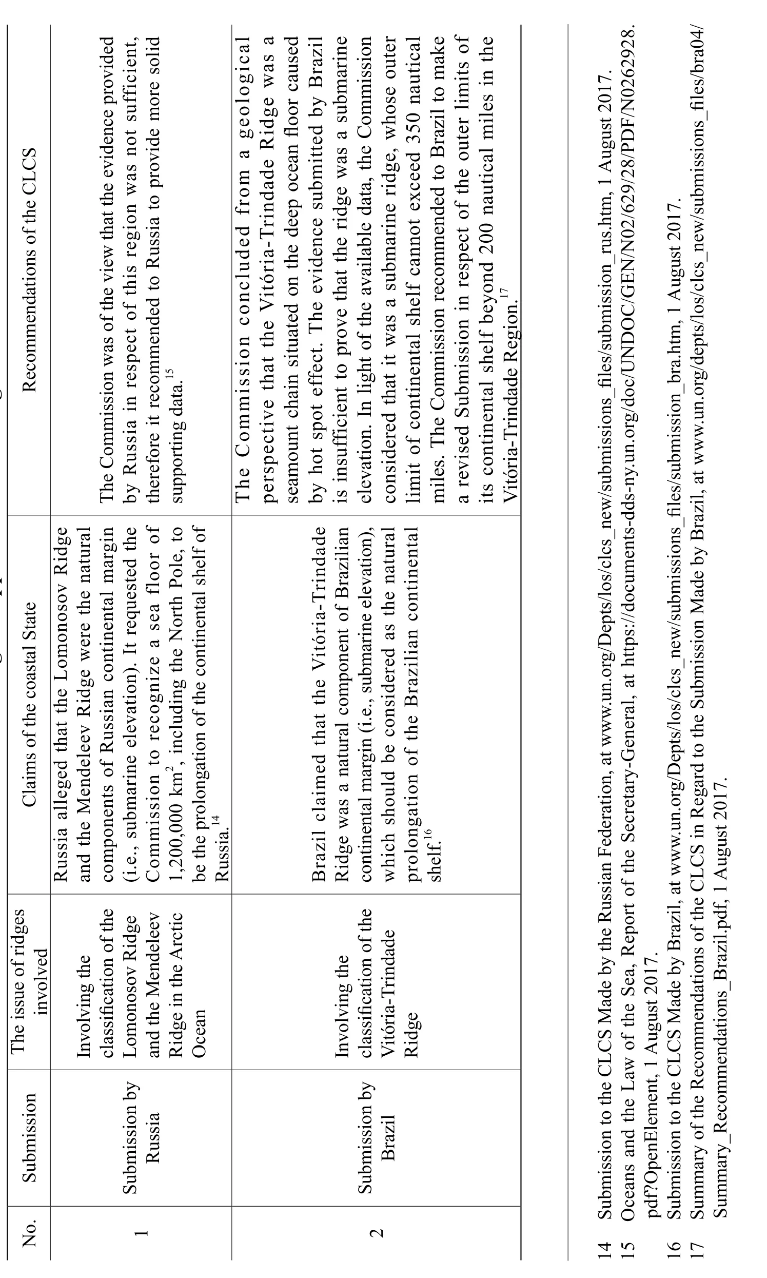
Table 1 Reviewed Submissions Involving the Application of the Ridge Provisions
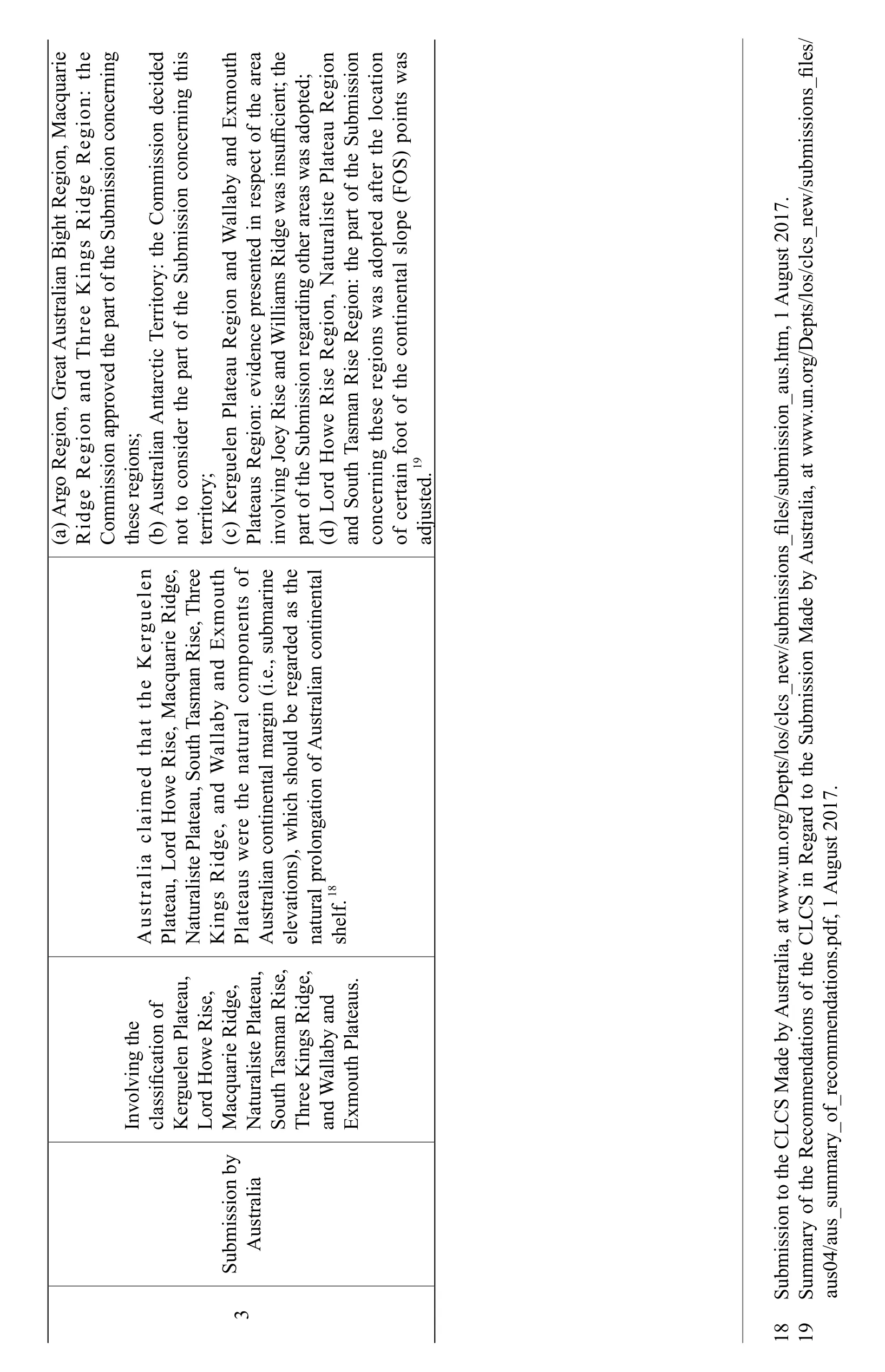
3 S u b m i s s i o nb y A u s t r a l i a I n v o l v i n g t h e c l a s s i f i c a t i o n o f K e r g u e l e n P l a t e a u,L o r d H o w eR i s e,M a c q u a r i e R i d g e,N a t u r a l i s t e P l a t e a u,S o u t h T a s m a n R i d i s e,T h r e e K i n g sR a n d g e,a n d W a l l a b y E x m o u t h P l a t e a u s.A u s t r a l i a c l a i m o w e d e R t h a tt h e K e r g u e i d l e g e,n P l a t e a u,L o r d H i s e,M a c q u a r i eR N a t u r a l i s t e P l a t e a u, S o u t hT a s m a n R i s e,T m o h r e e K i n g s R i d g e, a n d W a l l a b y a n d p o E x u t h f P l a t e a u sw e r e t h en a t u r a lc o m n e n t s o A u s t r a l i a nc o n t i n e n t a lm u l d b a r g i n (i.e., s u b m a r i n e e l e v a t i o n s),w h i c hs h o e r e g a r d e d a s t h e n a t u r a l p r o l o n g a t i o n o f A u s t r a l i a n c o n t i n e n t a l s h e l f.1 8(a) A r g e R o R e g i o n,G r e a tA T h u s t r a l i a n B g sR i g h tR i d e g i o n,M g i o n a c q u a r i e R i d g e g i o n a n d r e e K i n g e R e: t h e C o m m i s s i o na p p r o v e d t h ep a r t o f t h eS u b m i s s i o n c o n c e r n i n g t h e s e r e g i o n s;(b ) A u s t r a l i a n A n t a r c t i cT e r r i t o r y: t h eC o m n c o n m i s s i o n d e c i d e d n o t t o c o n s i d e r t h ep a r t o f t h eS u b m i s s i o c e r n i n g t h i s t e r r i t o r y;(c) K e r g u e l e n P l a t e a u R e g i o n a n d W a l l a b y a n d E x m o u t h P l a t e a u sR e g i o n:e v i d e n c e p r e s e n t e d i nr e s p e c to f t h ea r e a i n v o l v i n g J o e y R i s e a n dW i l l i a m s R i d g ew a si n s uffic i e n t;t h e p a r to f t h eS u b m i s s i o n r e g a r d i n go t h e ra r e a sw a sa d o p t e d ;(d a n c o ) L o r d H o w e R i s e R e g i o n,N a t u r a l i s t eP l a t e a u R e g i o n d S o u t hT a s m a n R i s e R n sw e g i o n:t h ep a r t o f t h eS u b m i s s i o n n n c e r n i n g f o t h o to e s e r e g i o a sa d o p t e d a f t e r t h el o c a t i o a s o fc e r t a i n f t h ec o n t i n e n t a ls l o p e(F O S)p o i n t s w a d j u s t e d. 1 9 1 8 S u b m m m i s s i o nt o t h eC L C S M a d e b y A u s t r a l i a,a t w w w .u n.o r g/D e p t s/l o s/c l c s_n e w n M /s u b m i s s i o n s_f i l e s/s u b m i s s i o n_a u s.h t m , 1 A u g u s t2 0 1 7.1 9 S u a r y o f t h eR a r y_e c o m m e n d a t i o n so f t h eC L C S i n R e g a r d t o t h eS u b m i s s i o a d e b y A u s t r a l i a, a t w w w .u n.o r g/D e p t s/l o s/c l c s_n e w /s u b m i s s i o n s_f i l e s/a u s 0 4/a u s_s u m m o f_r e c o m m e n d a t i o n s.p d f, 1 A u g u s t2 0 1 7.
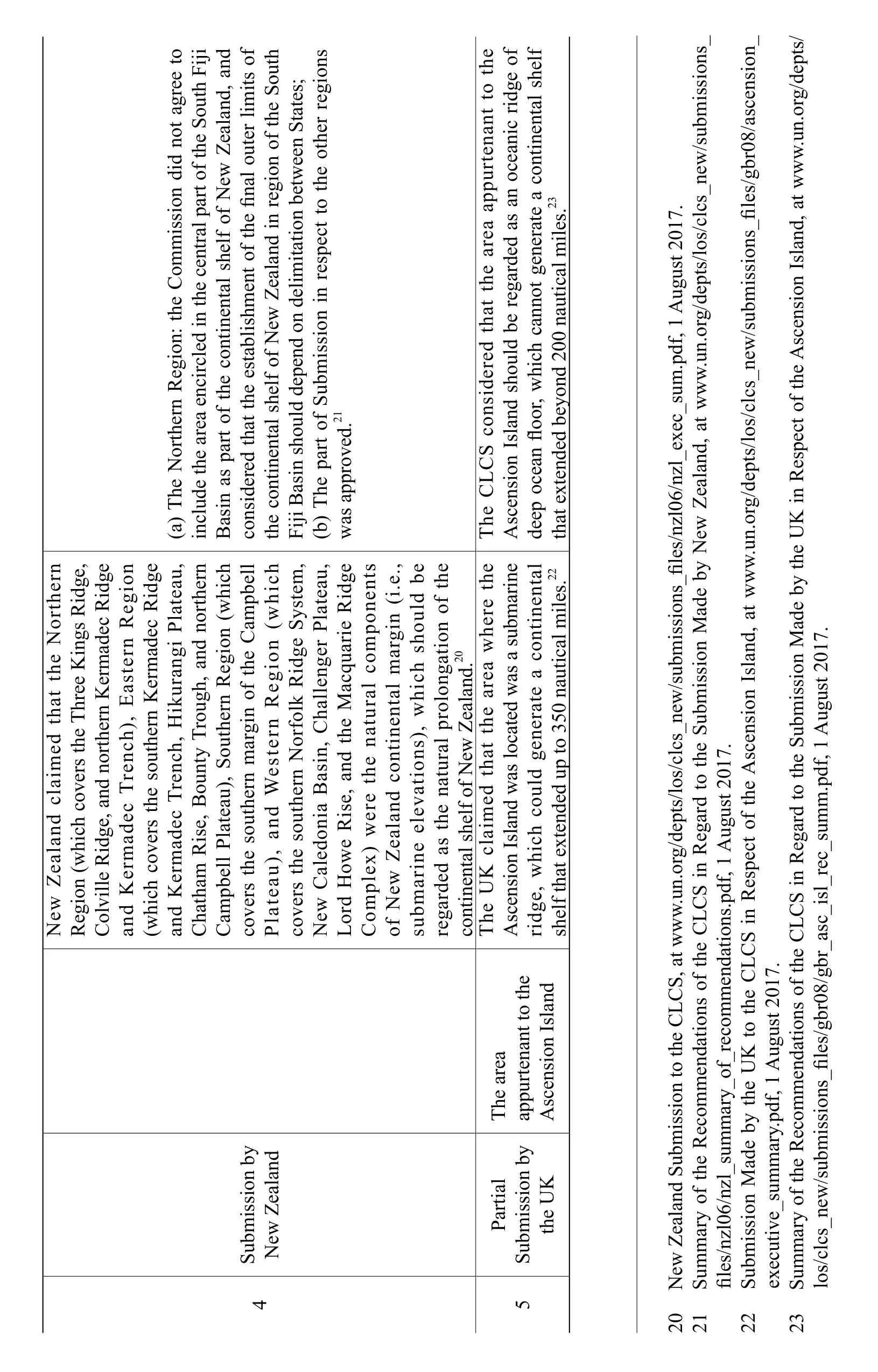
4 S u b m i s s i o nb y N e w Z e a l a n d N e w Z e a l a n d c l a i m e d t h a t t h eN g sR o r t h i d i d g e e r n R e g i o n(w h i c h c o v e r s t h eT h r e eK i n g e,C o l v i l l eR i d g e, a n d n o r t h e r nK e r m a d e c R g i o n g e,a n(w a n d K e r m a d e c T r e n c t h h), E a s t e r n R e h i c h c o v e r st h es o u e r n K i k u g e r m a d e c R i d d K e r m a d e c T r e n c h,H r o u r a n g iP n o l a t e a u C h a t h a m R i s e,B o u n t y T h,a n d i o r t h e r n C a m p b e l lP l a t e a u e r n m),S o u t h e r n R e g n (w h p b i c h c o v e r st h es o u n d t h t h a r g i n o f t h eC n (w h a m e l l h P l a t e a u), a W e s t e r n R l k e g R i d g g e r P i o i c c o N e w C H o l e v e r st h es o u i aB e r n N o r f o e S y s t e m,,a l e d o n a s i n , C t h h a l l e n l a t e a u g e L o r d m p e w a r i n w eR i s e,a n d e M r a a c q u a r i eR n e i d n t s C o x)w e r e t h e n a t u l c o m p o o fN b m Z e a l a n d c o n t i n e n t a lm a r g i n (i.e.,s u e e l e v a t i o n s), w r o h i c h a t i o s h o u l d f t h e b e r e g a r d e d a st h en a t u r a lp l o n g n o c o T h n t i n e n t a l s h e l fo f N t h e w Z e a l a n d.2 0(a) T h eN o r t h e r n R e g i o n:t h eC o m m i s s i o n d i d n o t a g r e et o i j i i n c l u d e t h ea r e a e n c i r c l e d i nt h ec e n t r a lp a r t o e w f t h eS o u t hF B a s i n a s p a r t o f t h ec o n t i n e n t a ls h e l fo f N Z e a l a n d,a n d c o n s i d e r e dt h a t t h ee s t a b l i s h m e n to f t h ef i n a l o u t e rl i m i t s o f t h e c o n t i n e n t a ls h e l fo f N e w Z e a l a n d i n r e g i o n o f t h eS o u t h F i j iB a s i ns h o u l d d e p e n d o n d e l i m i t a t i o n b e t w e e nS t a t e s;i o(b) T h ep a r t o f S u b m i s s i o n i n r e s p e c tt o t h eo t h e rr e g n s w a s a p p r o v e d.2 1 5 P a r t i a l S u b m t h e U i s s i o nb y K T h e a r e a a p p u r t e n a n t t o t h e A s c e n s i o n I s l a n d e U K c l a i m e d a tt h e a r e aw h e r et h e A s c e n s i o n I s l a n d w u l d g a sl o c a t e dw a sas u b m a r i n e r i d g e,w h i c h c o e n e r a t e ac o n t i n e n t a l s h e l f t h a t e x t e n d e d u p t o 3 5 0n a u t i c a l m i l e s.2 2 T h e C L C S c o n s i d e r e d t h a t t h ea r e a a p p u r t e n a n tt o t h e A s c e n s i o n I s l a n d s h o u l d b e r e g a r d e d a s a n o c e a n i cr i d g eo f d e e po c e a nf l o o r,w h i c hc a n n o t g e n e r a t e ac o n t i n e n t a ls h e l f t h a te x t e n d e d b e y o n d 2 0 0 n a u t i c a lm i l e s.2 3 2 0 N e w Z e a l a n dS u b m i s s i o n t o t h eC L C S,a t w w w L C .u n.o r g/d e p t s/l o s/c l c s_n e w /s u b m i s s i o n s_f i l e s/n z l 0 6/n z l_e x e c_s u m w w .p d f, 1 A u g u s t2 0 1 7.2 1 S u m m a r y o f t h eR e c o m m e n d a t i o n so f t h eC S i n R e g a r d t o t h eS u b m i s s i o n M a d e b y N e w Z e a l a n d,a t w.u n.o r g/d e p t s/l o s/c l c s_n e w /s u b m i s s i o n s_f i l e s/n z l 0 6/n z l_s u m m a r y_o f_r e c o m m e n d a t i o n s.p d f, 1 A u g u s t2 0 1 7.2 2 S u b m i s s i o n M a d eb y t h eU K t o t h eC L C S i n R e s p e c to f t h eA s c e n s i o n I s l a n d, a t w w w .u n.o r g/d e p t s/l o s/c l c s_n e w /s u b m i s s i o n s_f i l e s/g b r 0 8/a s c e n s i o n_e x e c u t i v e_s u m m a r y.p d f,1 A u g u s t2 0 1 7.2 3 S u m m a r y o f t h eR e c o m m e n d a t i o n so f t h eC L C S i n R e g a r d t o t h eS u b m i s s i o n M a d e b y t h eU K i n R e s p e c to f t h eA s c e n s i o nI s l a n d,a t w w w .u n.o r g/d e p t s/l o s/c l c s_n e w /s u b m i s s i o n s_f i l e s/g b r 0 8/g b r_a s c_i s l_r e c_s u m m .p d f, 1 A u g u s t2 0 1 7.
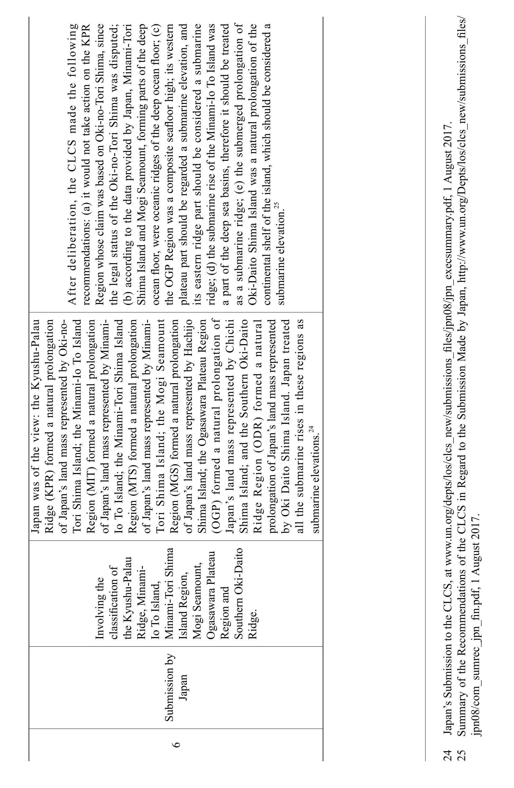
6 S u b m J a p a n i s s i o nb y I n v o l v i n g t h e c l a s s i f i c a t i o n o f t h e K y u s h u-P a l a u R i d g e,M i n a m i-I oT o I s l a n d,M i n a m i-T o r i S h i m a I s l a n dR e g i o n,M o g iS e a m o u n t,O g a s a w a r a P l a t e a u R e g i o na n d S o u t h e r nO k i-D a i t o R i d g e.J a p a n w a so f t h ev i e w:t h eK y u s h l o n g u-P a l a u n R i d g e (K P R)f o r m e d an a t u r a lp r o y O a t i o o-o fJ a p a n ’sl a n d m a s s r e p r e s e n t e db k i-n T o r iS h i m aI s l a n d;t h eM i n a m i-I o T o I s l a n d R e g i o n (M I T ) f o r m e d an a t u r a lp r o l o n g a t i o n i-o fJ a p a n’sl a n d m a s s r e p r e s e n t e db y M i n a m I oT o I s l a n d;t h eM i n a m i-T o r iS h i m aI s l a n d n R e g i o n(M T S)f o r m e d an a t u r a lp r o y M e a l o n g a t i o i-t o fJ a p a n’sl a n d m a s s r e p r e s e n t e db i n a m u n n T o r iS h i m a I s l a n d ; t h e M o g iS m o R e g i o n(M G S)f o r m e d an a t u r a lp r o l o n g a t i o o fJ a p a n ’sl a n d m a s s r e p r e s e n t e db y H a c h i j o S h i m G P a I s l a n d;t h eO g a s a w a r aP r o l a t e a uR e g i o n f(O) f o r m e d m d an a t u r a lp l o n g b y k i-D t u a t i o n o J a p a n’s l a n a s s r e p e S r e s e n t e d C h i c h i S h i m a I s l a n d;a n d t h o u t h e r n O a i t o l R i d g e R e g i o n (O D R)f o r m e d a n a r a p r o l o n g a t i o no f J a p a n’sl a n d m a s s r e p r e s e n t e d b y O k i D a i t o S h i m a I s l a n d.J a p a n t r e a t e d a l l t h es u b m a r i n er i s e si n t h e s er e g i o n sa s s u b m a r i n e e l e v a t i o n s.2 4 A f t e r d e l i b e r a t i o n,t h e C L C S m a d e t h e f o l l o w i n g r e c o m m e n d a t i o n s:(a)i t w o u l dn o tt a k e a c t i o n o n t h eK P R c e R e g i o n w h o s e c l a i m w a s b a s e do n O k i-n o-T o r iS a sd i n a m h i m a, s i n t e d;t h e l e g a ls t a t u s o f t h eO k i-n o-T o r iS h i m aw, M i s p u(b) a c c o r d i n g t o t h e d a t a p r o v i d e d b y J a p a n i-T o r i S h i m a I s l a n d a n dM o g i S e a m o u n t,f o r m i n g p a r t s o f t h ed e e p o c e a n f l o o r,w e r e o c e a n i cr i d g e s o f t h ed e e p o c e a n f l o o r;(c)t h e O G P R e g i o n w a s ac o m p o s i t es e a f l o o r h i g h;i t sw e s t e r n p l a t e a u p a r t s h o u l d b e r e g a r d e d as u b m a r i n ee l e v a t i o n, a n d i t s e a s t e r n r i d g e p a r t s h o u l d b e c o n i n a m s i d e r e d as u b m a r i n e a s r i d g e;(d)t h es u b m a r i n er i s e o f t h eM i-I oT o I s l a n d w a p a r t o f t h ed e e p s e ab a s i n s,t h e r e f o r ei t s h o u l d b e t r e a t e d o f a sas u b m a r i n er i d g e; (e)t h es u b m e r g e d p r o l o n a t i o g a t i o n f t h e O k i-D a i t o S h i m aI s l a n d w a san a t u r a lp r o l o n g n o c o s u n t i n e n t a l s h e l fo f t h ei s l a n d,w h i c hs h o u l d b e c o n s i d e r e d a b m a r i n e e l e v a t i o n.2 5 2 4 J a p a n’s S u b m i s s i o n t o t h eC L C S,a t w w w .u n.o r g/d e p t s/l o s/c l c s_n e w /s u b m i s s i o n s_f i l e s/j p n 0 8/j p n_e x e c s u m m a r y.p d f,1 A u g u s t2 0 1 7.2 5 S u m m a r y o f t h eR e c o m m e n d a t i o n so f t h eC L C S i n R e g a r d t o t h eS u b m i s s i o n M a d e b y J a p a n, h t t p://w w w.u n.o r g/D e p t s/l o s/c l c s_n e w/s u b m i s s i o n s_f i l e s/j p n 0 8/c o m_s u m r e c_j p n_f i n.p d f,1 A u g u s t2 0 1 7.
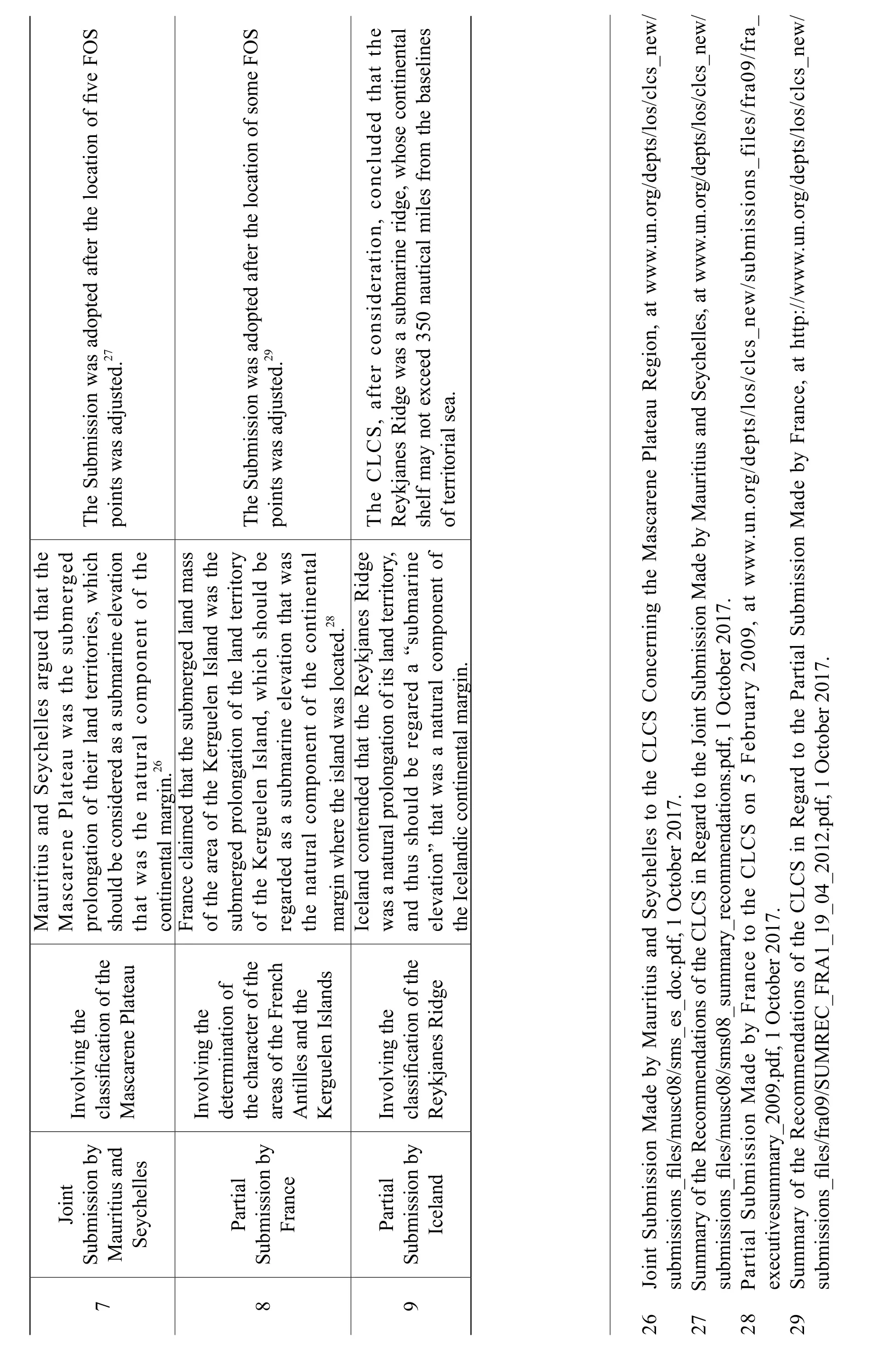
7 J o i n t S u b m i s s i o nb y M a u r i t i u s a n d S e y c h e l l e s I n v o l v i n g t h e c l a s s i f i c a t i o n o ft h e M a s c a r e n e P l a t e a u M a u r i t i u s a n d l a S e y c h e l l e sa r g u e d t h a t t h e d M a s c a r e n e P t e a u w a s t h e s u b m e r g e p r o l o n g a t i o no f t h e i rl a n d t e r r i t o r i e s, w h i c h s h o u l db e c o n s i d e r e d a s as u b m a r i n ee l e v a t i o n t h c o a tw a st h e n a t u r a l c o m p o n e n to f t h e n t i n e n t a l m a r g i n.2 6 T h e S u b m i s s i o n w a sa d o p t e da f t e rt h el o c a t i o n o f f i v eF O S p o i n t sw a sa d j u s t e d.2 7 8 P a r t i a l S u b m i s s i o nb y F r a n c e I n v o l v i n g t h e d e t e r m i n a t i o n o f t h e c h a r a c t e ro f t h e a r e a s o f t h eF r e n c h A n t i l l e sa n dt h e d s K e r g u e l e n I s l a n F r a n c ec l a i m e dt h a t t h es u b m e r g e dl a n d m a s s o ft h ea r e a o f t h eK a t i o e r g u n o e l e nI s l a n d w a st h e s u b m e r g e d p r o l o n g f t h el a n d t e r r i t o r y b e a s o ft h eK e d e r g u e l e n I s l a n d , w h i c h s h o u l d r e g a r d a sas u b m a r i n ee l e v a t i o n t h a tw t h m a r g e n a t u r a lc o m p o n e n to f t h ec o n t i n e n t a l i n w h e r e t h ei s l a n d w a sl o c a t e d.2 8 T h e S u b m i s s i o n w a sa d o p t e da f t e rt h el o c a t i o n o f s o m e F O S p o i n t sw a sa d j u s t e d.2 9 9 P a r t i a l S u b m i s s i o nb y I c e l a n d I n v o l v i n g t h e c l a s s i f i c a t i o n o ft h e R e y k j a n e s R i d g e I c e l a n d c o n t e n d e d t h a tt h eR e y k j a n e sR i d g e w a s an a t u r a lp r o l o n g a t i o n o f i t sl a n d t e r r i t o r y,e f a n e l e v d t h u s s h o u l d b e r e g a r e d a “s u b m a r i n a t i o n”t h a t w a san a t u r a lc o m p o n e n to t h e I c e l a n d i cc o n t i n e n t a lm a r g i n.T h e C L C S,a f t e rc o n s i d e r a t i o n , c g e, w o n c l u d e d t h a tt h e R e y k j a n e s R i d g ew a sas u b m a r i n er i d h o s ec o n t i n e n t a l s h e l f m a yn o te x c e e d 3 5 0n a u t i c a l m i l e sf r o m t h eb a s e l i n e s o ft e r r i t o r i a ls e a.2 6 J o i n t S u b m i s s i o n M a d e b y M a u r i t i u sa n d S e y c h e l l e st o t h eC L C S C o n c e r n i n g t h eM a s c a r e n eP l a t e a u R e g i o n , a t w w w .u n.o r g/d e p t s/l o s/c l c s_n e w /s u b m i s s i o n s_f i l e s/m u s c 0 8/s m s_e s_d o c.p d f,1O c t o b e r2 0 1 7.2 7 S u m m a r y o f t h eR e c o m m e n d a t i o n so f t h eC L C S i n R e g a r d t o t h eJ o i n tS u b m i s s i o n M a d e b y M a u r i t i u sa n dS e y c h e l l e s,a t w w w .u n.o r g/d e p t s/l o s/c l c s_n e w /s u b m i s s i o n u b s_f i l e s/m u s c 0 8/s m s 0 8_s u m m a r y_r e c o m m e n d a t i o n s.p d f, 1O c t o b e r2 0 9 0 1 7.2 8P a r t i a lS m i s s i o n M a d e b y F r a n c e t o t h eC L C S o n 5 F e b r u a r y 2 0, a t w w w .u n.o r g/d e p t s/l o s/c l c s_n e w /s u b m i s s i o n s_f i l e s/f r a 0 9/f r a _e x e c u t i v e s u m m a r y_2 e c o m 0 0 9.p d f,1 O c t o b e r 2 0 1 7.2 9 S u m m a r y o f t h eR m e n d a t i o n so f t h eC L C S i n R e g a r d t o t h eP a r t i a lS u b m i s s i o n M a d e b y F r a n c e,a t h t t p://w w w.u n .o r g /d e p t s/l o s/c l c s_n e w/s u b m i s s i o n s_f i l e s/f r a 0 9/S U M R E C _F R A 1_1 9_0 4_2 0 1 2.p d f, 1O c t o b e r2 0 1 7.
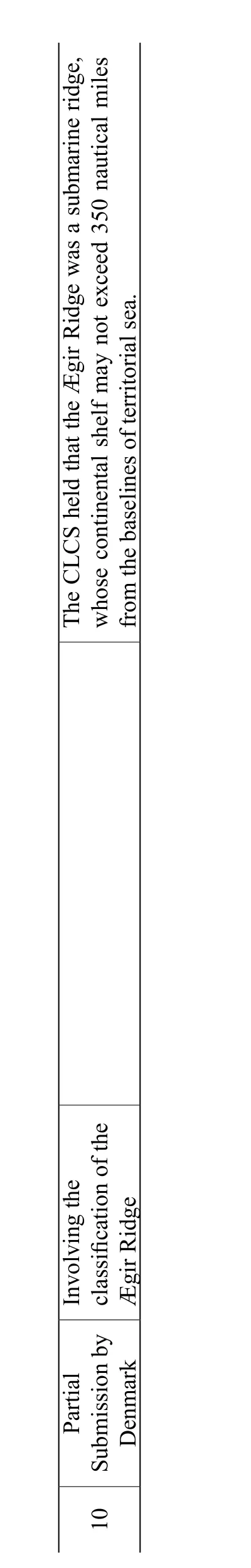
1 0 P a r t i a l S u b m D e n m i s s i o nb y a r k I n v o l v i n g t h e c l a s s i f i c a t i o n o ft h e ? g i rR i d g e T h e C L C S h e l d t h a t t h e? g i r R i d g ew a sas u b m a r i n er i d g e,w h o s e c o n t i n e n t a ls h e l fm a y n o t e x c e e d 3 5 0n a u t i c a l m i l e s f r o m t h e b a s e l i n e so f t e r r i t o r i a ls e a.
B. Analysis of Some Representative Submissions
Among the Submissions reviewed by the CLCS, the Submissions made by Japan, the UK, and Iceland are particularly noteworthy. Japan, invoking the ridge provisions under UNCLOS Article 76, claimed seven regions, including the Southern Kyushu – Palau Ridge Region (KPR) and the Ogasawara Plateau Region(OGP). The area Japan claimed as its extended continental shelf was 747,000 square kilometers, almost twice of its land area.30FANG Yinxia, TANG Yong and FU Jie, Commission on the Limits of the Continental Shelf with Regard to Japan’s Submission: A Commentary, China Oceans Law Review,No. 2, 2013.The UK, Iceland and other island States also invoked the ridge provisions to claim a continental shelf that extended to 350 (or more) nautical miles from the baselines from which the breadth of the territorial sea was measured. And Iceland even claimed that the continental shelf of its southern Reykjanes Ridge could extend up to a distance of 700 nautical miles. Such Submissions require further examination and scrutiny. The following pages will review the claims of the coastal States and the recommendations of the CLCS, with a view to exploring the principles guiding the application of the ridge provisions.
1. The Submission by Japan
Japan presented its Submission to the CLCS on 12 November 2008.31Japan’s Submission to the CLCS, at www.un.org/depts/los/clcs_new/submissions_files/jpn08/jpn_execsummary.pdf, 1 August 2017.Japan’s Submission mainly included seven regions located to the south and the southeast of its main islands, namely, the Southern Kyushu – Palau Ridge Region (KPR),the Minami-Io To Island Region (MIT), the Minami-Tori Shima Island Region(MTS), the Mogi Seamount Region (MGS), the Ogasawara Plateau Region(OGP), the Southern Oki-Daito Ridge Region (ODR) and the Shikoku Basin Region (SKB). Among the seven regions, the OGP Region overlaps with the MTS Region, hence Figure 1 actually shows six regions. According to the Summary of Recommendations of the CLCS released on the UN website,32Summary of Recommendations of the CLCS in Regard to the Submission Made by Japan, at www.un.org/Depts/los/clcs_new/submissions_files/jpn08/com_sumrec_jpn_fin.pdf, 1 August 2017.as regards to the seven regions claimed by Japan, (a) the CLCS decided not to take action on the KPR Region whose claim was based on Oki-no-Tori Shima, since the legal status of the Oki-no-Tori Shima was disputed; (b) the continental shelf of the MGS and MTS regions, located in deep sea basins, should not extend beyond 200 nautical miles; (c) parts of the claimed areas of the MIT, OGP, ODR and SKB Regions were modified and adopted by the CLCS. (Fig. 2)
Almost all the seven regions claimed in Japan’s Submission involve the application of the ridge provisions, in particular, the classification of the submarine rises where KPR, MGS, OGP and MTS are located, since it decides the maximum extent of continental shelf that a given region may claim. The claim of the KPR region was made on the basis of Oki-no-Tori Shima; the CLCS decided not to take action on it due to the disputed legal status of Oki-no-Tori Shima. Considering the complex topography of the OGP Region, which involves the application of multiple ridge provisions, the following paragraphs will primarily analyze this region.

Fig. 1 Areas of the Extended Continental Shelf Claimed by Japan in Its Submission

Fig. 2 Areas of Extended Continental Shelf Claimed by Japan in Its Submission as Adopted by the CLCS
The OGP Region included the eastern flank of the Izu – Ogasawara Arc, the Ogasawara composite high, and the Uyeda Ridge. In Japan’s view, (a) this region was the natural prolongation of the Minami-Io To Island land territory on the Shichito-Io To Ridge and the Ogasawara Gunto Islands on the Ogasawara Ridge,and a submarine elevation that could be considered as a natural component of the continental margin where Izu – Ogasawara Islands was situated; (b) the region was a complex, composite sea floor high composed of several seamounts, and divided into the western plateau part, the eastern ridge part, and the southeastern seamount part. The Ogasawara plateau part in the west was at that moment colliding with the Izu – Ogasawara Arc and clogging up in the area where the Mariana Trench joined the Izu – Ogasawara Trench. The eastern ridge part lay at similar depths to the western plateau part and hosted a series of seamounts from west to east. At the depth of 2500~3500 meters, the western plateau part and the eastern ridge part were morphologically continuous. The southeastern part was a relatively isolated group of seamounts.33FANG Yinxia, TANG Yong and FU Jie, Commission on the Limits of the Continental Shelf with Regard to Japan’s Submission: A Commentary, China Oceans Law Review,No. 2, 2013.
The Subcommission, based on morphology, agreed that the plateau part and the ridge part were continuous. It also pointed out that, due to plate movement and subduction, the western plateau part had been accreted to the Izu – Ogasawara Arc,which was a submarine elevation within the meaning of Article 76, suitable for the application of the depth constraint constructed at 100 nautical miles from the 2,500 m isobath. However, the eastern ridge part ran into the deep ocean floor in the Pacific Ocean. It was originally formed in the oceanic environment far from the subduction zone and the associated island arc, and as such shared the characteristics of the deep ocean floor. The ridge part should not be regarded a submarine elevation but a submarine ridge, and therefore subject only to the 350-nauticalmile distance constraint. The southeastern group of seamounts was not surmounted by islands, and was a normal part of the typical deep ocean floor. These seamounts were considered to be oceanic ridges of the deep ocean floor, which should have no continental shelf beyond 200 nautical miles.34Summary of Recommendations of the CLCS in Regard to the Submission Made by Japan, at www.un.org/Depts/los/clcs_new/submissions_files/jpn08/com_sumrec_jpn_fin.pdf, 1 August 2017.
2. The Submission by the UK
The UK made, on 9 May 2008, its Submission to the CLCS regarding the limits of the extended continental shelf appurtenant to Ascension Island.35Submission Made by the United Kingdom of Great Britain and Northern Ireland in Respect of Ascension Island on 9 May 2008, at www.un.org/depts/los/clcs_new/submissions_files/gbr08/ascension_executive_summary.pdf, 1 August 2017.Ascension Island is a dependency of the British Overseas Territory, which lies on the mid-ocean ridge of the southern Atlantic Ocean. It is comprised of a principal island and several affiliated features.
The UK was of the view that the Mid-Atlantic Ridge (MAR), formed by seafloor spreading, was a submarine ridge. The UK considered that the natural prolongation of the Ascension Island extended to, and along the MAR, and the FOS of the Ascension Island should be located on the outer edge of the MAR and deep ocean basin margins. Based on that, the UK intended to extend the continental shelf of the island up to 350 nautical miles by using the 60-nautical-mile distance formula and the 350-nautical-mile distance constraint.36Summary of Recommendations of the CLCS in Regard to the Submission Made by the UK in Respect of Ascension Island on 9 May 2008, at www.un.org/depts/los/clcs_new/submissions_files/gbr08/gbr_asc_isl_rec_summ.pdf, 1 August 2017.
The CLCS disapproved the UK’s claim of extended continental shelf for the Ascension Island, holding that the MAR was a part of the deep ocean floor of the Atlantic Ocean, and the FOS of the Ascension Island, to the extent possible,could be only located on the maximum change of gradient in the base of insular slope of the island, rather than the base of the MAR. Grounded on these facts, the CLCS concluded that the Ascension Island cannot generate a continental shelf that extended beyond 200 nautical miles.37Summary of Recommendations of the CLCS in Regard to the Submission Made by the UK in Respect of Ascension Island on 9 May 2008, at www.un.org/depts/los/clcs_new/submissions_files/gbr08/gbr_asc_isl_rec_summ.pdf, 1 August 2017.The recommendations of the CLCS in regard to the Submission made by the UK in respect of Ascension Island provide a special demonstration effect and have great historical significance, since they curb the intentions of some States which attempt to overextend their continental shelves by making use of the ridge rule, and protect the common heritage of mankind.
3. The Submission by Iceland
On 29 April 2009, Iceland made its Partial Submission to the CLCS in respect of the ?gir Basin area and the western and southern parts of the Reykjanes Ridge.38Submission Made by Iceland in the ?gir Basin Area and in the Western and Southern Parts of Reykjanes Ridge on 29 April 2009, at www.un.org/depts/los/clcs_new/submissions_files/isl27_09/isl2009executivesummary.pdf, 5 August 2017.In its Submission, Iceland stated that the geomorphologic characteristics and geochemical data of the Reykjanes Ridge showed that the ridge was a natural component of the Icelandic continental margin – “submarine elevation”. Based on that, Iceland contended that the 2500 m isobath + 100 nautical mile constraint criterion should be applied, and its continental shelf may extend up to a distance of 700 nautical miles, from the baselines from which the breadth of the territorial sea was measured.
On 10 March 2016, the Commission released the summary of its recommendations on the Submission made by Iceland.39Summary of Recommendations of the CLCS in Regard to the Submission Made by Iceland in the ?gir Basin Area and in the Western and Southern Parts of Reykjanes Ridge on 29 April 2009, at www.un.org/depts/los/clcs_new/submissions_files/isl27_09/2016_03_10_sc_isl.pdf, 5 August 2017.It gave the following recommendations with respect to the Reykjanes Ridge: the Commission did not agree with the Iceland’s claim that the Reykjanes Ridge was a natural component of the Icelandic continental margin – “submarine elevation”; instead, the Commission asserted that the ridge, formed by sea floor spreading of the mid-ocean ridge, was an integral part of the North Atlantic sector of the Mid-Atlantic ridge system, rather than a natural component of Icelandic land mass. Reykjanes Ridge should only be regarded as a submarine ridge, and as such the outer limits of its continental shelf may not exceed 350 nautical miles from the baselines from which the breadth of the territorial sea was measured.
IV. Analysis and Some Reflections
It is rather complex to define the character of a sea floor high, specifically, to decide whether it belongs to an “oceanic ridge of the deep ocean floor”, a “submarine ridge” or a “submarine elevation”. Article 76 only provides for the entitlements of these three types of ridges to continental shelves, leaving the precise definition and distinction of the three open for further elaboration. The logic of this article seems plausible, but it is difficult to implement it in practice. Such a legal provision adds difficulties to the work of the CLCS, and at the meantime, leaves spaces for coastal States to scramble for larger continental shelf. When classifying a ridge into a particular type of sea floor highs in the legal sense, we need, firstly, follow the original intention of the lawmakers in drafting the ridge provisions, and take into account the geological characteristics and origin of the ridge. The three types of ridges under Article 76 were formed in different geological processes and tectonic settings. They have both legal and scientific meanings. Hence, a number of documents, including the Guidelines, have mentioned the geological characteristics and formation process of ridges. The Commission also feels that in cases of ridges its view shall be based on scientific and legal considerations.
A look into the history of the creation of the ridge provisions and the pertinent researches indicates that:
(a) Both submarine elevations and submarine ridges may be elongated bottom features;
(b) Geological differentiation between submarine elevations and ridges is possible, however, the criteria are not clear. Purely sedimentary (both of continental or oceanic origin) features are undoubtedly elevations, while ridges are exclusively formed by the geological processes of the ocean crust;40Tomasz Górski, A Note on Submarine Ridges and Elevations with Special Reference to the Russian Federation and the Arctic Ridges, Ocean Development & International Law, Vol. 40, Issue 1, 2009, pp. 51~60.
(c) The differentiation of the three types of ridges should not be solely based on the relevant provisions of the UNCLOS. Instead, more importance should be given to the history of the preparation of such provisions, because it reflects the intentions of the treaty makers;41Tomasz Górski, A Note on Submarine Ridges and Elevations with Special Reference to the Russian Federation and the Arctic Ridges, Ocean Development & International Law, Vol. 40, Issue 1, 2009, pp. 51~60.
(d) The outer edge of the continental margin of a coastal State, i.e., the submerged prolongation of that State’s land mass, is established by applying the provisions of Article 76(4) through measurements from the FOS. Seafloor highs that lie beyond the outer edge of the continental margin are considered part of the“deep ocean floor with its oceanic ridges” in the sense of Article 76, paragraph 3;42Harald Brekke and Philip Symonds, Submarine Ridges and Elevations of Article 76 in Light of Published Summaries of Recommendations of the Commission on the Limits of the Continental Shelf, Ocean Development & International Law, Vol. 42, Issue 4,2011, pp. 289~306.
(e) The distinction of these types of ridges should be made on the basis of the geological characteristics of the ridges and their geomorphological continuity with the land mass of the coastal State. Based on geological and geophysical evidence,an assessment should be made as to what extent a ridge is geologically associated or continuous with the land mass of the coastal State, and to what extent it is geologically different to the surrounding deep ocean floor.43Harald Brekke and Philip Symonds, Submarine Ridges and Elevations of Article 76 in Light of Published Summaries of Recommendations of the Commission on the Limits of the Continental Shelf, Ocean Development & International Law, Vol. 42, Issue 4,2011, pp. 289~306.
The Commission attempted to expound the relevant matters in chapter 7 of the Guidelines. However, it admitted that it was difficult to define the details concerning various conditions, therefore it stated that “the issue of ridges [should] be examined on a case-by-case basis.”44Ron Macnab, Submarine Elevations and Ridges: Wild Cards in the Poker Game of UNCLOS Article 76, Ocean Development & International Law, Vol. 39, Issue 2, 2008,pp. 223~234.The delimitation practices of coastal States and the recommendations rendered by the Commission tell that: (a) the coastal States, for the sake of their own interests, tend to broadly construe the ridge provisions. If the claimed area possesses any land territory above water, the coastal State concerned would try every means to prove that the claimed area is a submarine elevation which is a natural component of the continental margin; if the claimed area is located at the deep ocean floor, the State concerned would endeavor to demonstrate that the area is a submarine ridge which has morphological continuity with any oceanic islands. (b) The recommendations given by the Commission in respect to the Submissions would impose tremendous impacts on the rights and interests of the coastal States, therefore, the Commission, when rendering its views, has always adopted a cautious attitude and strictly interpreted the UNCLOS. In case of the determination of the type of a ridge, the Commission, adopting the same attitude,gives its view based on the data submitted by the coastal States, as well as the morphological and geological structure and origin of the ridge.
Due to the definitional uncertainties presented by the UNCLOS, and the failure of the Guidelines to provide a final solution, the scholars are still researching on the method to define the ridges under Article 76. According to the researches of these scholars and the recommendations of the CLCS, the distinction among the three types of ridges under Article 76 is decided mainly by their morphological and geological structures.45Harald Brekke and Philip Symonds, Submarine Ridges and Elevations of Article 76 in Light of Published Summaries of Recommendations of the Commission on the Limits of the Continental Shelf, Ocean Development & International Law, Vol. 42, Issue 4,2011, pp. 289~306.When defining the types of ridges, one should base its view on the following considerations: (a) the morphological characteristics of the ridge and its location relative to the continental margin, i.e., the morphological continuity; (b) A ridge’s geological continuity with the land mass of the coastal State. A submarine elevation is morphologically and geologically continuous with the land mass of the coastal State. In general, a feature can be regarded to be the natural component of the continental margin on the basis of its geological characteristics, in addition to its already proven morphological continuity with the land mass of the coastal State. The assessment is made primarily on the basis of geological and geophysical evidence. The assessment is also made as to what extent a seafloor high is geologically associated or continuous with the land mass of the coastal State, and to what extent it is geologically different to the surrounding deep ocean floor. If a feature is morphologically continuous with the land mass of the coastal State, but there are not enough geological/geophysical data and direct evidence available to sufficiently substantiate its classification as a submarine elevation that is a natural component of the continental margin, or the feature has a different evolution and geological character from that of the adjacent land mass, then the feature should be considered as a submarine ridge. If a feature is morphologically discontinuous with the land mass of the coastal State, and has a different evolution and geological character from that of the adjacent land mass,then it should be classified into an oceanic ridge of the deep ocean floor. This view is being widely accepted. At present, the practical application of the ridge provisions is largely based on the delimitation practices of the coastal States and the recommendations given by the CLCS to coastal States on matters related to the establishment of the outer limits of their continental shelves.
V. Conclusions
The issue of continental shelf beyond 200 nautical miles relating to ridges has been regarded as one of the most complex and contentious parts of UNCLOS Article 76. A coastal State may greatly extend its outer edge of continental shelf beyond 200 nautical miles by making use of the ridge provisions. In addition, the mid-ocean ridge regions may potentially provide enormous economic interests,therefore, an increasing number of coastal States are attempting to, by invoking the ridge provisions, extend their continental shelf to the maximum extent. Article 76 merely provides for the entitlements of the three types of ridges to continental shelves, leaving the precise definition and distinction of the three open for further elaboration. Actually, it is very complex to define the character of a sea floor high,specifically, to determine whether it belongs to an “oceanic ridge of the deep ocean floor”, a “submarine ridge” or a “submarine elevation”. In this context, the CLCS declared that the issue of ridges should be examined on a case-by-case basis. Considering the intentions of the makers of the ridge provisions, the relevant literature and the recommendations of the CLCS with respect to the delineation of continental shelf, we can know that the character of a ridge is primarily determined by its morphological and geological structure, i.e., morphological and geological continuity. In short, a sea floor high which is both morphologically and geologically continuous with the land mass should be regarded as a submarine elevation; a feature which is only morphologically continuous with the land mass should be classified as a submarine ridge; and a feature which is neither morphologically nor geologically continuous with the land mass should be considered an oceanic ridge of the deep ocean floor.
Translator: XIE Hongyue